Has anyone done Winner Creek and come out 20 mile yet this year? Wondering what conditions are like AND is this a one day or two day trip? Thanks.
This is a tough little trip – not the trail, and not the vertical bushwhacking, but the fork to the 20 Mile is skinny, fast, and filled with sweepers. Many have been dumped, some dangerously so. You can do it in a day, but it would be quite dark by the time you get back to the hwy. An overnighter, with plenty of dry extraclothes, waterproof bags, flashlite, tide table book and many matches. Don’t go alone – even if you’re a hunk. You might need someone to fish you from the bottom. The big river is easy, if the wind and tide aren’t against you. Don’t miss the pull-out.
JJ
I got Posercraft into the water for her maiden voyage this past Sunday. A friend who has also recently been lured by the Alpacka Siren Song came along.
The day started as expected, good and cloudy.

The cloudy edges of this photo were not done on purpose. I think they add a nice touch to allow the reader to realize how wet it really was along the trail.
We moved at a reasonable clip, reaching the pass in about 3 hours after crossing 4 or 5 snow patches. There was only one where I thought about taking out a paddle as a makeshift ax. But the snow was just soft enough to kick steps in with tennis shoes.

The pass area, sucker holes were appearing with more regularity.
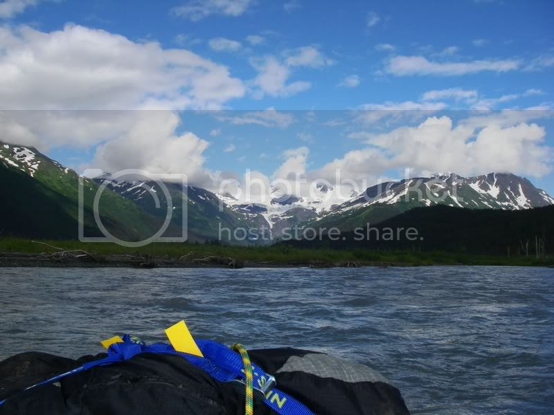
After a not too awful bushwhacking (it was all downhill after all) session found us popping out onto this little beauty of a launching spot!

Complete with raging sunshine which we took full advantage of to dry out our soggy bodies.
The initial start was fun but we had to get out for 4 or 5 sweepers. One was marked with tape, the others were not and were easily maneuvered around. From there the river widens and slows and it became time to soak up the almost rarely seen scenery of this valley.

I’m amazed at how agile and responsive my Yukon is. I’m hooked 
btw… 10 hrs 50 min from Aleyska tram to highway.
Great to check in for a Winner Creek/20 Mile trail report and have one posted just a couple days before we head out. Nice pix. Now we just need to hold out for some of that sunshine. It sounds like the sweepers weren’t bad?
I’m not sure that my experience level allows me to be a great judge of how bad the sweepers were. Given this was my first real packraft trip, I thought they were pretty tame. But my level of risk acceptance might be different than yours.
They were all clearly visible and you could take out easily around all of them, with only one exception. The second sweeper we encountered blocked the main, right channel and from upstream we couldn’t really tell if there was a way through or not. So we crossed the main channel to a gravel bar, pulled out and took another look. There was a small channel to the left that we determined if we could cross the main channel and get to the smaller left one, that would go with a possible brush with some alders on the bank.
I shoved off first and with 3 or 4 quick paddles was right where I wanted to be and did indeed brush a few branches on the far shore, but not a big deal. This was the moment I realized how awesome these boats really are, super responsive and you can place them right where you want 'em. I then took out again to watch my partner who also made the narrow channel easily.
Remember too that the number of sweepers you encounter is going to be dependent upon where you put in. We walked along the river for a bit (1/4 mile?) before finding a nice spot to put in. There were other places you could do a put in, just not as comfy as the one we found. I’ve got a coordinate. If you’re interested, PM me.
Oh, and have a great trip!
Thanks for the report! I was going to wait until next summer to give this one a try, but that plan may change. A friend and I are considering using our yaks as a way to float out after a goat hunt along that route at the end of this month. My only concern is the responsiveness of my boat when heavily loaded in the event we happen to be successful (an extra 150 pounds?). When you say the sweepers were visible beforehand, can you estimate how far in advance you saw them? I just don’t want to get myself in a dicey situation, but trips such as these are exactly what motivated me to get a boat in the first place.
Problem solved, take me on your goat hunt!!
I have a feeling low water might be more of an issue that time of year than the sweepers, at least on the East Fork section. 
We definitely were bumping our butts some and it looked like the water was at a higher than average level.
You could see the sweepers from a fair distance out, like maybe 100 meters, maybe more? I’ve got good eyesight and a high level of paranoia for sweepers so I was scanning as far into the distance as I could. They were readily visible and gave plenty of time to take out to get around. Personally, I don’t think getting down this creek with an extra 150 lbs in the boat would be too much of a problem. But I’ve not paddled with an extra 150 lbs before, so take that info with that grain of salt.
The sweepers were concentrated very close to where we put in, maybe even within the first 3/4 mile or so, maybe 1/2 mile. When we first started it was like 2 bends, sweeper, another bend, sweeper, two more bends, sweeper. I was beginning to wonder what time we would finish. But the river opened up quickly after the sweepers and then there were no more.
Again, it’s important to note that the number of obstacles you will encounter is heavily dependent upon where you put in at.
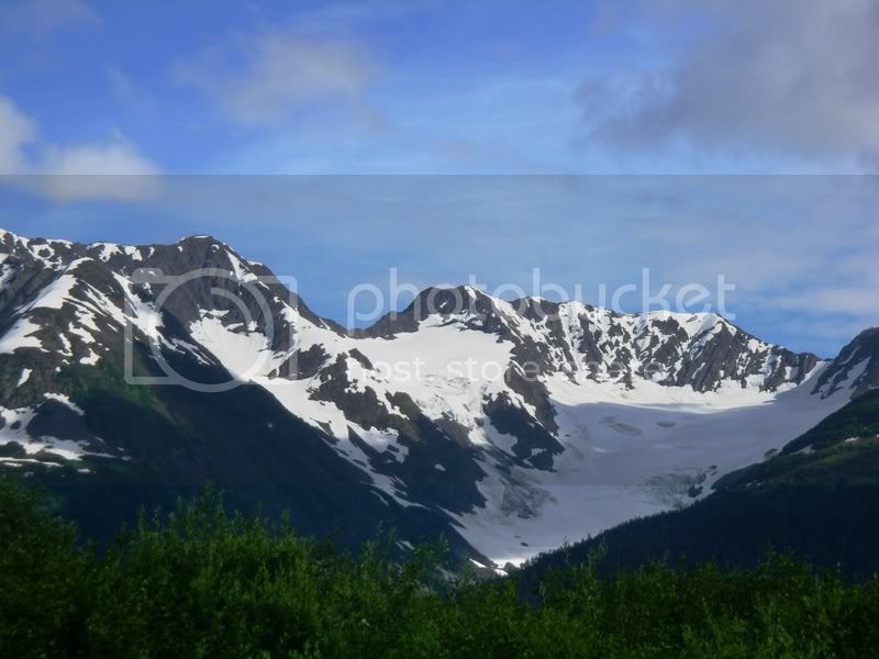
We ended up doing this trip as an overnight and spent a rare (this summer anyway) beautiful evening up on the pass. I hadn’t been on this trail in a couple years and was again amazed at the views that greet you at the top. My first time down the other side, I was surprised at how well “established” the path was downhill; much less of a bushwack than I was expecting. Lots of good, calf-deep muds holes added to the fun though. From the looks of it, we put in at a spot just below where you did, bergbryce. As you said, all the sweepers are within the first half mile or so and all are easily scouted and avoided. Within this half mile, my partner had a bit of a mishap with her paddle (it broke!) but as luck/divine intervention would have it, I happened to find a brandnew AquaBound on the rockbar I was scouting from. (Crazy…like Twilight Zone crazy.) I think we would have been able to jerry-rig her broken paddle but, wow, was this a lot easier! So away we went, hooked up with the main channel of 20-Mile and had a serene float out. Saw one blackie on the shore and lots of sunshine.
btw did anyone misplace an AquaBound paddle on the feeder stream of 20-Mile?
IMG_3372.jpg
IMG_3389.jpg
IMG_3394.jpg
I believe that’s my paddle!! Around about July 20th a friend and I were packrafting there and we both dumped not long after putting in, just after the first few bends. A cottonwood was blocking the entire tributary at that point. Our stuff went everywhere, but we managed to find everything but one paddle (which was borrowed from a friend…oops.) I believe it still had remnants of a price tag on it from REI if I remember right. We looked for it for awhile, but ended up just bushwacking back out…
My number is 830.0609 and I will gladly pay you a finder’s fee!
Tracy
Finder’s fee? No way! We should be thanking you for the loan!
PM sent.
Floated 20-Mile on Sunday with a large crew. 8 packrafters on the river… and only 5 power boats!
Followed this guys tracks from Alyeska to 20-Mile – but never actually met him.
20 Mile 8_24_08104_8_1.jpg
Finley- Followed your bear tracks today and wondered if they were recent and if we’d run into yogi. Good to know they were old. That new sweeper (not there last year) in the first two minutes came up fast and furious but we bailed just in time onto the log and did some balancing acts to get across. We spent some time chopping at the 2nd one last summer and gave up when we hit the water line. Someone should bring in a bigger saw to finish the job… it’s almost done, and now there’s a second sweeper to work on. There’s also a ton of Salmonberries on the trail so if anyone needs a hike/packraft/berry fix, now’s the time to go. The crew of 8 seemed to have done some work on the bushes but there’s still plenty left to be had under the canopy.
Did Winner Creek to Twenty Mile yesterday for the first time in a few years. A little cool and soggy, but plenty of water in the river for this time of year. There is a new (to me anyway) false trail to watch out for on the hike down to the river.
About halfway down from the pass to the river, we came upon a patch of tall grass where the trail appeared to take a sharp left hand turn, just before a patch of alders. “That’s funny, the trail didn’t go that way last time,” I thought. Every time I had done this trip previously, I had bushwhacked straight for about 25 yards through the alders to where a pretty good trail picks up again in the hemlocks. But even so, the new trail to the left looked well-trodden. I knew better, but it was too tempting - we gave the new trail a try. After about five minutes, it worked its way back to the creek and then began to peter out as people’s paths took different routes to skirt along the top of the creek gorge. After ten minutes we gave up and went back to the original trail, which was as good as ever.
Not sure why that new trail is there. Were people scouting/running the creek? It’s gnarly up that high.
Anyway, this isn’t a big deal, but hopefully this will help others avoid wearing in a trail that, as far as I can tell, goes nowhere. Bust through the alders, its much better on the other side.
Floated Twenty Mile today. The Upper Winner Creek trail is really a treat, but the false passage faked us out and we spent 40 minutes bushwhacking down the creek side before we ambled out into the clearing that had orange flags on it. The river is low - a lot of dragging. There are hardly any sweepers/strainers that pose any real risk,though.
I skied/floated Winner Creek to 20 Mile last week and was pleasantly surprised at how much water 20 Mile had in it. Winner creek was mostly open with a couple of sections still covered in ice but easy going. Snow stability on the Southern face(20 Mile side) of the pass was excellent. Getting to where you can put in on 20 mile requires numerous crossings to stay on the easiest ice/snow on the shore lines. Other than rubbing bottom a couple of times I was able to put in approximately 5-6 miles from the pass. Good trip!
I hadn’t been down the 20Mile in years and did it recently. I haven’t seen any posts on here talking about the new trail segment off the back of Berry Pass going down towards the 20Mile. I say “towards the 20Mile” because it is a real sandbag.
The trail switchbacks quite nicely down what used to be a nasty, steep bushwhack. You get great views on this trail, whereas before you couldn’t even see your feet. It appears that the trail work was done late last summer (2010), as some of the ancient hemlocks felled still had needles on them. (It is worth checking out the tree rings on these hemlocks as several of the trees are over 400 years old.)
As the new trail approaches the creek coming out of Punch Bowl it just stops. I guess the money ran out because it is a very strange spot for the trail to end. What seems like it would be a short swhack to the 20Mile is one of the nastiest Devil’s Club thickets I’ve encountered. We spent a bad hour thrashing around before finally locating the lower end of the old trail.
I suggest that you peel off the new trail before you get to the end. Ideally, locate the old trail where it takes off from the new trail. Or, if you get to the end of the new trail, head back uphill and see if you can find the old trail. I don’t know if it is flagged because I wasn’t watching for it. The frickin’ Forest Service needs to put a warning sign on that trail because it is a total sandbag.
We did this a few weeks ago and found the route relatively easy to follow once the trail ends. It looks like they ran out of time or money, as the route is flagged the whole way (we retied a few of the flags that were on the ground), and cleared of trees and brush for at least part of the route. Once the trail ends, you should be able to follow the route by looking for the flags and evidence of cut trees and brush. The route heads to a creek that flows into the 20 mile, then follows it downstream along the edge of a steep cliff overlooking the creek. At some point the trail drops down a steep section (at this point no longer a cliff but more just a steep slope) to creek level, so keep a sharp eye out for flags. Once at creek level find your way through the brush to the creek.
We ended up following this creek downstream (sometimes on the bank, sometimes in paths through the alders) until it’s confluence with the 20 mile. This creek may be runable, but we had seen some significant rapids upstream and decided to play it safe by walking the short distance to the 20 mile. There was at least one tree blocking the whole channel on this creek after a corner, so walking to the 20 mile might be the best option for inexperienced paddlers? (There are no flags once you hit this creek, so just pick your own route if you decide to hike the short distance to the main channel of the 20 mile).
The flags should be on the route all the way to the creek, but the trees/brush are cleared only partway. The key for us was to stay on the flagged route; the extra time searching for flags was worth it in the long run as it avoids the worst of the bushwhacking (it was more like following a game trail rather than full on bushwhacking). You should be able to see flags along the whole route, but some of them are not always obvious and might take a minute or two to locate.
I did this trip about a month ago. It had been a few years for me as well. We also followed the flagging almost until we hit the steep bluff overlooking the creek that runs nto the twentymile. We bushwacked down to the creek and tried to make it to the twentymile itself but the alders were too thick. We put in on the creek right after a creek wide conifer sweeper. The creek was swift class II with two more alder sweepers that you could paddle around and it joined the twenty mile in like a quarter or half a mile.
I’ve spoken to some folks who used work for the FS about the abrupt ending of this awesome new trail. This trail may never be completed down to the twentymile because it’s intended extension is actually to continue along the west bluff of the main twentymile all the way to the highway (someday). If packrafters want a good trail to the river we may have to contact the FS and see if we can put it in ourselves.
Ryan Hickel