Upper Ngaruroro, Central North Island, NZ

Upper Ngaruroro River, Central North Island, NZ

We recently completed a trip in January down this amazing section of untouched river that is only accessible on foot. It is occasionaly run by rafters and kayakers who typically charter a plane in from Taupo.

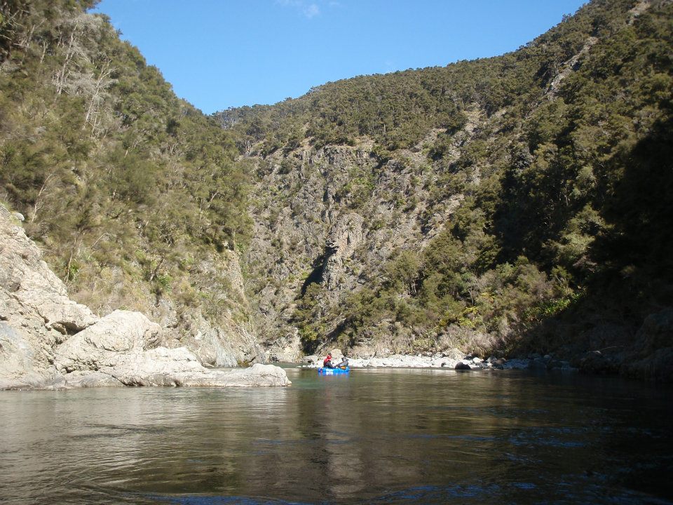
The Ngaruroro begins in the Kaimanawa Ranges, travels through the Kaweka Forest Park and eventually out to the coast between Napier and Hastings. The Kaweka forest has a network of tracks providing access to about 5 places along the river. There are three access roads at different corners of the park. This allows heaps of trip options from 2 days to about 10 days. There are 5 cosy (DOC managed) NZFS huts along the river and many more throughout the park. There are also some great natural hot springs.

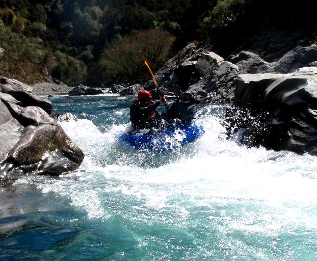
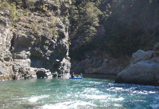
The upper river runs through a narrow, steep sided, winding valley, covered with sections of red beech forest and Manuka / Kanuka forest, along with some cool rock outcrops. The upper section, from Boyd hut to Kuripapongo, is about 50kms in length and falls evenly at about 10 m / km (about 50 ft / mile). Guide books have classed the Upper Ngaruroro at Grade 2, however in our opinion there are a few grade 3’s, although all easily portagable.

We completed a 6 day trip including 3 days of tramping followed by 3 days packrafting. We walked in from the Te Puia hot springs road end, up the track beside the Mohaka River (another great trip possibility in itself), up the ridge to Makino hut, South East to Mangaturutu hut, Tira hut and down to Rocks Ahead hut, beside the Ngaruroro river. A longer trip could involve tramping across to Boyd hut instead, giving an extra 2 days on the river.

When we went, the river had recently been in flood. By the time we got to the river, the water was running clear but I think higher than normal, especially for this time of year. They say the top part of the river is too shallow for rafts during late summer, but would be fine for packrafts any time i think.

We had 3 awesome days on the river, each about 4 - 5 hours, including lunch. I’m sure people do it a lot quicker, however we just enjoy cruising. We also scouted and portaged quite a bit as we are beginners, its really remote country, steep river and we had big packs.

Our takeout was at Kuripapongo on the Napier - Taihape road. The trip could have been continued below this, however the river is more technical (there is a grade 4 rapid) and this section is run by commercial rafting operators.

I’d definitely reccomend this trip as a remote wilderness experience (as far as NZ can provide!), where you will hardly see another person, except the occasional hunter. Further reading would be Graham Charles, “NZ White Water”, and Graham Eggar, “North Island Rivers”.

Tim

Thanks for the post Tim, sounds like a great trip! Any photos?

Tim - I am impressed. With a big pack that would have been some work to get to your put in. And its remote alright for limited experience. Good on you for getting after it.

We did a 3-day trip in October 2011 from your take out down about 50km - me in an Alpacka Yak and 3 mates in an incept raft. We had 2 nights camped by the river; the first one was a challenge finding a good spot given the gorgey nature of the river at that point. The second camp, at the confluence with the Taruarua, was a beaut. We took out fly rods but spent most of the time paddling. We got a few fish but expected to see more given the remoteness.

I’m no whitewater specialist but I made it ok with only 2 swims. I certainly had to focus - the beauty of the river and the gorge helped me chill out between rapids.

I’d be keen to walk up into where you were at some point, or even further. I see its about a 55km paddle from the tussock-banks around Boyd Hut to the road and imagine its fairly slow going in that sort of territory compared to the more braided sections further down (below the Taruarua). I think I would have to be convinced there would be more fish around to make it worth the effort!

I have some pictures that I will try to load. Its an absolutely gorgeous river.

Cheers

Hi Haydn / Virtual,

We had a real dissappointment with our camera on this trip, on the second day the battery died, so we have no photos of this trip beside some really blurry ones i took with my phone. Will just have to do it again some time!

Two of us went down in an alpacka and llama and yeah the packs felt heavy on the walk in, but totally worth it for the river. Yeah, progress was slow, there were rapids ever hundered metres or so, kept us focussed.

Virtual, the lower part you did sounded awesome and with stunning scenery. Were the bigger rapids portagable?

Has anyone been down the Mohaka by packraft?

Tim

Pictures from from the Ngaruroro trip we did from Kuripapango (well at least I hope they uploaded!) below.

Tim, for the gnarlier rapids on the Ngaruroro, I tried to make sure my “support raft” went first! And then I followed. Some areas there were no portages - but to be honest I didn’t even look for them, and maybe I should have and avoided my swims.

I haven’t been down the Mohaka yet but I think that a walk in through Poronui Station (14km), staying at the Oamaru Hut then rafting down to exit at either Pakaututu (42km rafting) or Mountain Valley at SH5 (59km rafting) would be a great 4-day trip. However, because its private land on both banks from about 1km down from the hut there would be about 25km of rafting in the first day to get to your first legal campsite (on DOC land at the confluence with the Mangatainoka River). Helisika flies in hunters and fishermen to these private blocks and so I think they would get upset to find packrafters camped in there. A 25km day would be huge by my measure requiring diligence and perseverance, and being more feasible with long daylight hours. My mate has done the trip down from Mangatanguru Stream upteen times in his incept raft (taking a Helisika chopper in - thats where they will drop you off) and says it would be fine for packrafting - but I would be prepared for a swim or portages.

Cheers.


Ngaruroro trip October 2011 - 4 edit.jpg

Hi Timlusk,

That sounds awesome mate. I’m going to give it a go this summer.

Can you tell me how you arranged transport? Or did you leave cars at either side of the Kaweka’s? I’m hoping I can arrange someone from Napier to drop us off, and then hitch back to Napier afterwards.

My plan is to start from end of Kaweka Rd on east side of the range, walk 1day (12km) across the range to Rocks Ahead Hut, then spend a lazy 3 days floating down to Kuripapango.

Cheers
Chris