Sticks and Stones - a trip down the upper Picton to Farmhouse Creek.
The Picton is probably the best local river if you live in Hobart. Great for daytrips, not very hard at low levels, but interesting enough for non-experts at higher levels. Two sections of about 10 km, allowing options on trip length. No significant hazards and the lower section finishes at a tourist attraction with hot food and drinks available, so it seems really comfortable. Having enjoyed the normal Picton sections a few times, the thought of packrafting the river from its source in the Southern Ranges seemed like a great idea and something perhaps achievable in a long weekend. The Paddle Tasmania website said for trip time, based on the only know trip ‘1 day paddling + access.’ How long could ‘access’ take?
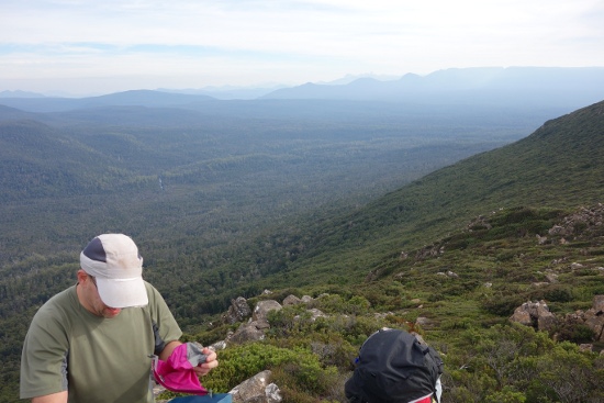
Bruce and I met at Huonville at 6.00 in one car each. Being mid-May, it was still dark but Huonville had lots going on and there were busy people everywhere. With great discipline we avoided a bakery stop and drove down to Geeveston and on to Top Bridge, mid-way between the two normal Picton sections to leave a car there. From there we went on to Mystery Creek cave at the start of the Southern Ranges walk and got onto the track about 9.00. Had a pretty good walk up to Moore’s Bridge and over to Moore’s Garden, both of which are amazing features with large expanses of cushion-plant and pineapple grass to walk over. There was only one section of mild scrub where there is an old, cut semi-track through the Scoparia and dwarf myrtle. We found a reasonably sheltered spot to camp about half way along Moore’s Garden and got set up by sunset at 5.00. There had been forestry burnoffs so the red sunset over Federation Peak, the Eastern Arthurs and Mount Picton was really good.
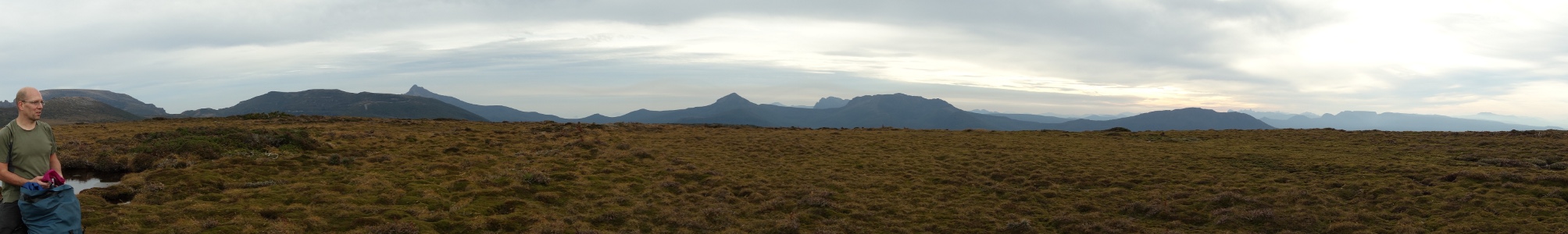
We got away by 8.00 the next morning and walked on over to Mt Alexandra. There is a slightly worn set of tracks that humans and wombats have made leading to the summit. From there on it was trackless. We followed the western side of the rocky ridge leading to a saddle (GR 787 934) that we had identified as a good place to descend towards the river from. The only trip we knew of down the Picton from this high up was done by two kayakers in the 1990s who had been able to get their kayaks and gear helicoptered in to our riverside target point for entering the river (open buttongrass / tea tree clearing at GR 765 937) when they were doing vegetation survey work in the area. They then walked in and kayaked down. Being Hobart residents, I knew them both and went to have a chat to one of them about it. Comments like ‘you could do it in a day’ for the walk stick in my mind.
The ridge beyond Mt Alexandra had a few short scrub sections and one bit at the top of a knoll of about 200 m that had been conveniently incinerated in the previous summer’s bushfires, making for easy walking. We got to the descent point at 11.30 and put gloves on in readiness for the scrub bash to the river entry point, which we could see clearly in the valley below us. I was already wearing my helmet. We’d both done a long trip into the Denison the previous October entering the river at a point high up near Algonkian Peak and our hands really suffered there. The Jane river track and up and over Algonkian Peak and part of the Prince of Wales range took four very hot days of drinking crayfish-burrow water and having our extremities slashed by cutting grass, tea tree and all sorts of other things, but that’s another story… and it made me think that the 2 km downhill through the dense forest here couldn’t be as bad as uphill over Algonkian Peak.
The descent started through Scoparia and myrtle and the first ten minutes seemed reasonably promising. It soon started getting over head height and slowed us a fair bit despite the steep downhill gradient. Then we had a band of tea tree, which was thick, but we’ve had worse on Algonkian Peak. After about an hour we hit the horizontal scrub and rainforest. From this point on, we very rarely saw the ground and walked on a mixture of fallen logs decomposed to a wide range of states, but all covered in moss and slime so that it wasn’t possible to tell whether it would take your weight until you stood on them. Some sections were piles of mostly rotten material that you could sink to your armpits in and struggle to get out of like you were in deep semi-refrozen snow. Other sections would take your weight, but were covered in centimetres of algal-fungal-bacterial slime that lubricated them incredibly so your foot would slip on any section without a crevice or branch to stop you. There was also a lot of horizontal scrub to crawl and climb through. In places this was a three-dimensional grid of up to 5 m high and you’d spend a lot of time way above ground level. If this let up it would be over-head-height cutting grass. Overall, the most difficult and unpleasant walking I’ve done. We got up onto a fallen giant eucalypt around 3.30 that had taken out a lot of tall trees nearby when it fell so we managed to get a GPS reading and a view of the river entry point. The GPS showed that we’d gone about 800 m in the last four hours and there wasn’t much daylight left. We went on for a bit and got a drink at a stream, then forced ourselves on until it was close to dark. Somewhere along here I realised that one of the paddle sections tied to the outside of my pack had been claimed by the forest. Luckily we’d borrowed a spare paddle or things would have seemed pretty grim then. One of the only positives of this forest was water availability and we found a trickle when the light got too low to continue and had to stop there.
There wasn’t enough room to pitch the two-person tent we’d brought. We were in a huge pile of rotten logs of various dimensions and states of decay. We found a couple of semi-level spots on minor log piles under huge fallen trees. Bruce got out his packraft for a groundsheet and put the tent inner over a log to go above him as a tarp. I wrapped the tent fly under and around my sleeping pad and bag. After a great rehydrated meal and a few heartening swigs of Glenmorangie, we crawled into our log-cave sleeping arrangements and awaited the dawn 13 hours away. Somewhere around here the forest claimed one of Bruce’s gloves as well. There were mosquitos. There were leeches, although they only liked Bruce’s Canadian blood. It didn’t rain, so that was good.
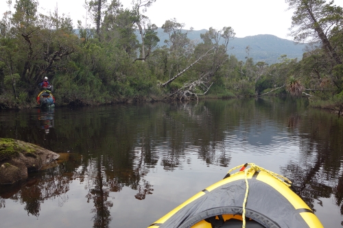
The dismal forest continued for another few hours the next day, then gave way to lighter tea-tree and cutting grass and beyond that suddenly opened out into the buttongrass and sparse tea-tree open patch that we’d been aiming for. The two km forest section had taken about nine hours of full-body-exercise crawling-walking-arm swinging damp, slippery unpleasantness. I didn’t like it. We got to the river edge around 11.00 with some relief. After about 40 minutes we’d put on semi-dry suits (leechproof, ha) and got the rafts and packs arranged.
The night before we set out, so three days before, the river level at Tahune had been 0.9 m. It looked pretty scratchy from the start and was. The river had fallen to 0.7 m at Tahune we discovered later. There was a lot of getting out of the boats and dragging them. The water is dark brown here and full of dark brown rocks. The Picton flows north and the sun was low in the sky as it was winter. With the sun always in our eyes, the river being low and not flowing very fast, we’d strike a hidden rock every ten metres or so on average and have to wriggle around to get off if it wasn’t too bad, or if properly stuck get out of the rafts and stand to get going again. There were some short fun-ish sections with nice little drops on them, but a lot of dragging and carrying rafts. Around 3.00 we realised we weren’t going to do the whole 40 km to the car in a day and started looking for camping spots. We’d hoped to do a two night trip, but had brought extra food for a third if things turned out like this. The tent spot was pretty good and we got set up, had a meal and into the tent just before it started to rain.
We really wanted a lot of rain to raise the river, but although it sounded like a bit in the tent, the river only came up 5 cm or so overnight. On the water at 8.00 and the river did get a bit more flow as the sides steepened and the catchment area increased, although we were still getting whacked by stealthy rocks with great regularity. There were some amazing Huon Pine groves on the banks, but we didn’t have any time to stop and appreciate them. The gorge sections further down were really nice with some good rapids. We did a lot of these, but ended up portaging the best looking one because the level of the river revealed a really sharp, raft-slashing rock right in the middle of the final problem that you’d only miss with difficulty. Around 2.00 we came to a freestanding pillar that is a great feature in this stretch of river. The main flow goes to the right of this at this level and could probably be done, but at higher levels there are dangerous log strainers here. We portaged. Beyond this there were quite a few decent rapids, most of which we ran. Approaching one, Bruce was ahead and got out to inspect it. When I got there he said ‘do you want to check it’ but I was getting lazy and the sun was in my eyes, so I just went with it and ended up having a good swim, although I didn’t loose the raft or paddle and with my torso up on the raft I got my legs smacked into by only about five rocks before I could eddy out about 40 m downstream. Shortly after that we realised we weren’t going to make it to the car and were just aiming for Farmhouse creek by nightfall. After a long-seeming few hours of frustratingly close to fun boulder gardens that we kept going aground on we finally got to Farmhouse creek at 4.00.
We divided the labour here. Bruce did a few trips up and down the river access track to get the gear up to the road while I walked the 12.3 km to the car and retrieved that. We reversed the car shuttle and each got to our homes by 10.30 or so. Very tired, bruised and scratched.
The river is actually really nice and with a level of 1 m or more at Tahune should be mostly raftable without all the dragging we had to do. I only remember one log jam we had to avoid and all of the problems are easily portageable. Access to the river is the main difficulty. Helicopters aren’t allowed into the World Heritage Area for recreation, so the best bet would be to get good at parachuting and jump in to the clearing we entered the river at from a fixed-wing plane (watch the trees). If you can take the idea of the walk, do it in summer with long days and be prepared for some challenges.
Simon Jarman and Bruce Deagle, May 2013.
Bruce’s photos are here:
https://picasaweb.google.com/115665096870038122408/Picton?authkey=Gv1sRgCMfmuPveiu_cNQ#