The wrong way to get to the Denison River.
October 2012. Andrew Stirling, Bruce Deagle, Joel Pedro, Klaus Meiners and Simon Jarman
Everyone who does the Denison River seems to like it. It is remote, beautiful and has only moderate difficulties once you are on the water. We wanted to try it too. The normal route across lake Gordon and over the Canoeist Track from Pearce Basin was out for us as we didn’t have a big boat to deliver us to the other side of the lake and flat-water paddling the packrafts over there seemed hard. On maps, it also looked like there could be nice sections further up the river so we’d come up with a plan that involved walking over Algonkian Peak in the Prince of Wales range to access the river about 30 km upstream from the normal access point. We had eight days for the trip and thought the walk would take about 2-3 of those, leaving us plenty of time to explore and enjoy the river before being picked up by the yacht Stormbreaker at Heritage Landing.
We all met at Klaus’s house in South Hobart at 7.00 and after a quick coffee managed to squash all five huge packs sitting upright into the back of one Honda CRV and all the people in the rest of the car as well. After some quick farewells we hit the road and were at the Derwent Bridge roadhouse for last-minute milkshakes, pies etc. by about 9.30. It was a really great, sunny day and the forecast was good for the next four days. At this stage we were only worried about water levels in the river being high enough. We drove on from Derwent Bridge and down into Surprise Valley. The road drops steeply towards the Franklin River entry point and the start of the Jane River Track that we were going to take near to that. The road provides a great altitudinal transect of South-West Tasmanian vegetation types that we were going to become intimate with over the coming days. With a little bit of searching around we found what we were pretty sure was the start of the Jane River track and parked the car around 11.00.
While we got ready there was a bit of pack weight comparison going on. I had the lightest pack, partly from taking as little as I could get away with and partly because I’d opted for a weird arrangement. I had a 70L rolltop, frameless portage pack (SealLine ‘Boundary Pack’) with the top not rolled up so that there is a lot more space, although obviously you have to hope it doesn’t rain hard, and everything held inside by strapping a foam sleeping mat over the open top. The paddle shafts and solidly-packed bag made it pretty rigid and with a waistbelt stolen from a proper pack this only weighs about 1.4 kg, so it is lighter, although less comfy than a real backpack. The portage pack fits really well on the front of the packraft. Anyway, with this arrangement I knew my pack was 26 kg as I’d weighed this at home. We didn’t have scales by the roadside, but I’m pretty sure none of the other blokes packs were less than 30 kg. It seemed like Joel might have brought some of his favourite lead bricks with him.
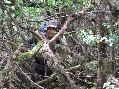
We had to do a bit more searching to make sure we were on the Jane River Track and once we were sure, the 20 min or so to the Franklin crossing was a nice easy start. I knew a couple of fellows who’d been along the Jane River Track about ten years ago and they’d taken mountain bikes to get to the Algonkian Peak access and been able to ride them for most of the track. Within 200 m of the Franklin crossing it became clear that things have changed since then. There were lots of tangles of fallen eucalypts across the track that we had to climb over or crawl through. We saw a few Tiger Snakes along here. Where there weren’t fallen eucalypts, there was a lot of re-growth shrubbery that is starting to reclaim the track. This old mining access road is (apparently) deliberately not marked on recent editions of maps for the area as the managers of this region don’t want to give the impression there is a formed track there. We came across and abandoned tarp and heavy camping gear like a full-sized frying pan right on the track. At this stage this all seemed pretty hard and slow, like any first day of a walk with big packs on. The old track is still a lot better than the surrounding bush, however, so we did make reasonable time and ended up at Erebus Rivulet just before dark at around 8.00.
The campsite beside the Erebus was really nice. Klaus and Joel had a good spot for the big tarp they were sharing. Bruce had trees for his hammock. Andrew had a flat spot for his bivvy bag and I had one for my little one-man tent. The rivulet is really nice there and is packraftable from that point for anyone thinking of doing the Jane River. Bruce made a macaroni and cheese thing for dinner. It was awesome. We slept.
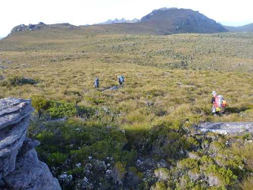
The next day we reached the old gold prospector’s hut after about two hours. This had a lot if interesting old and relatively new things lying around. We stopped for a snack and to read some of the books and articles about the area lying around in there. Then on to the start of the ridge for accessing Algonkian Peak. We took a little time making sure we were in the right spot and then bashed across the tea tree and eucalypt and on up to the ridge. Before long we got into some reasonably dense horizontal scrub and began to use our arms to progress almost as much as our legs. This was annoying, but there was worse to come. We reached the transition to tea tree, which generally gets me excited about height being gained, but something was distinctly different. It was dense tea tree. Really dense and it had thin, but quite strong vines growing horizontally through the dense uprights making a near-impenetrable mesh of vegetation. Joel climbed a big Banksia that poked above the general level of the tea tree and said ‘I think it’s just a narrow band.’ The narrow band continued for a kilometre or so of really hard pushing that took several hours. You had to put all your body and packweight into getting through some sections. Eventually after inhaling several kilos of the tea tree-scrub dust we broke out into a more open buttongrassy ridge and followed this a way trying to keep to the rockier outcrops. We had our first views Diamond Peak, the best feature in the Prince of Wales range from here and it was getting dark soon so we camped at about GR 052 203. I made a tomato pasta with bacon thing for dinner.
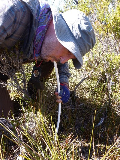
Shortly after leaving camp, we started to get great views of Frenchman’s Cap. From here you can see the cliffs straight on instead of the profile view that you get from the Lyell Highway. It was really hot, above 30 degrees C as we discovered later. We went on up scrubby ridges with long sections of Scoparia-rich scrub interspersed with cool groves of the best King Billy pine I’ve seen in Tasmania. These were a real relief for getting out of the sun, but were generally too short to give much respite. We did find a small stream in this section, but we started here to have to drink from Crayfish burrows. If you’re not familiar with SW Tasmania, a lot of it has burrowing crayfish of about 5-15 cm length that dig deep burrows with large water reservoirs up to a few m deep. In many places, this activity lowers the water table and the only surface water around is the small pool at the entry point to these burrow systems. Without these the trip would have been impossible. A couple of us had water bladders with transparent hosing that we could disconnect and use to drink from the little pools, which are generally only 5-10 cm wide. We also worked out that you can use the Alpacka raft spray skirt plastic tubes for this, although not being transparent, if you are not careful with watching the intake you swallow mud and algae.
We got to the summit of Algonkian Peak around 1.30 after an all too short section of alpine-type buttongrass and rock slabs. We had some lunch and took it easy for a bit. Nice views from there and the weather was remarkably good, but the walking had been pretty hard so we were dreading the next bit and couldn’t relax too much. We could see a steep descent through thick myrtle-rich rainforest after a couple of hundred metres of King Billy and Scoparia that looked pretty dense and damp. It really was, but that wasn’t as bad as the cutting grass and eucalypt forest that followed that. Eventually we escaped this to a buttongrass and tea tree saddle and found a mediocre campsite round GR 056 237. Joel cooked up a great Chorizo, tomato and pasta thing. There was a stream about 80 m away and we got our cooking water from that. The foam mat that was holding all the gear in the top of my pack was disintegrating pretty badly by now from being caught on so many abrasive branches. I slept on the remaining fragments supplemented by my wetsuit.
The next morning, shortly after breakfast, Andrew started vomiting powerfully. He was adamant that he’d be alright and we headed off. If fact a few of us felt nauseous so some water we’d had must have been bad. Andrew walked on with the stoic endurance of a Roman galley slave even though none of us were whipping him or beating drums. There was a bit more vomiting. The fairly good semi-open buttongrass and tea tree kept turning into deep saddles of impassable tea tree. Some of these were really, genuinely impassable without cutting equipment and we just had to find ways around them.
Andrew could only produce sentences with water-related nouns. And a lot of the verbs and adjectives were discouraging with regard to his hydration state as well. ‘I’m sure there is a stream just over there’ for example. There were no streams. It was all crayfish burrow territory here, but Andrew was understandably reluctant to drink from them given that this may have started his trouble in the first place. He was also reluctant to stop and boil some of the water from these because he didn’t want to slow us down. The other four of us mind-melded on this issue however and eventually persuaded him to lie down under a tarp for sun protection while we boiled up some burrow water. Once again it was over 30 degrees. We unfortunately didn’t have any re-hydration salts, so we had to improvise some by boiling up some Biltong (like beef jerky) with sugar in the water. Although this may sound disgusting, the salt and sugar mix did seem to help and after a while Andrew looked a bit better. Joel had scouted ahead and found a rainforest spot further along the ridge where we could get proper shade, although still no running water at GR 033 235. This was a really nice campsite and features some of the tallest Pandani I’ve seen, around 8-12 m high.
I should backtrack here to explain some things. This was our first multi-day packrafting trip. I had got inspired to buy a packraft on a solo walk in the Tyndall Range nine months earlier where you can see how good it would be to walk to somewhere like the headwaters of the Murchison River and raft down it. I went ahead and ordered one as soon as I got home. If you’re going to do anything with whitewater then the next thing you need, of course, is some other packrafters to go on trips with so I had to get some. I took my new Alpacka raft on a day trip down the Derwent with Klaus in a Canadian Canoe, Bruce in his ‘super caravelle 2000’ budget raft and got them all to try the Alpacka out. Some interest developed. Then I took it to Klaus’ birthday party weekend at Cloudy Bay where we could take it out in the surf. No takers yet… some suggestions that I should become a sales rep. for Alpacka rafts. So, I got serious about it, dreamed-up this Denison trip, had all the likely candidates over for whisky and inspiring conversation and three of them ended up ordering rafts. It was pretty good whisky. Joel was keen too, but had borrowed one for this trip and bought one himself subsequently. So, at this point after three days of hard walking and more to go after I’d estimated the walk at 2.5 days and Andrew without any food or much liquid in him and every day being hot… etc. I felt a bit responsible. But the great thing about growing your own packrafters like this is that you can choose the right characters for coping with adversity. Everyone still had a sense of humour and taking blokes like this on these grueling trips is really essential if you want to have fun.
We spent a fair bit of time talking about contingency plans that night. We were running out of time to meet the yacht that was going to pick us up at Heritage Landing. Also, at this point Klaus mentioned that the day after we were due back was his new girlfriend’s birthday. This was a strategic error on his part as it gave us lots of spirit-lifting options for teasing him, but that was great for the rest of us. We thought of taking the river 30 km to the normal put-in point for kayakers/rafters who cross Lake Gordon, walk over the hill and then paddle across lake Gordon, but that seemed as hard as just going out to Heritage Landing on the Denison/Gordon. The thought of walking back the way we’d come was too horrifying to consider seriously.
It was great to have a half-day rest and we got a few jobs done. Bruce had been getting eaten by mosquitos in his hammock and I realised I had a mesh bag I’d been keeping things in in my pack that would work as a headnet, so I got that out and gave it to him. I think this might have been better received if he’d got it before the fourth night out, ha ha. Klaus had just been away on a long scientific research voyage studying Antarctic sea ice and charming a lady and his packraft had arrived while he was away. He’d only got back from this a few days before we left on this trip, so he still had to lace the seat in his raft and he did that here. In trying to take the lightest gear, I had taken nylon mesh-topped approach-type shoes and these were falling apart from the demanding scrub they were being forced through. Also the narrow last of the shoes was conflicting with my wide feet. I spent an hour or so sewing up my shoes and taping over the toes that had lost their nails. We had another meal based on pasta, tomatoes and nitrate-heavy meat cooked up in crayfish burrow water, quite a lot of whisky and turned in after agreeing to an ‘alpine start.’
We got up around 4.30 to get going and up the steep section ahead of us before the sun got onto it. This was the steepest climb on the walk and had lots of rocky sections in it, but this was far better than the scrub on Algonkian Peak and when we reached the top it was a pretty clear buttongrass ridge from there on to the point we were going to descend to the river from (GR 019 249). We walked along this for forty minutes or so and got our first views of the Denison River valley, which is wide and impressive here. It was getting really hot again. Joel had an excess of youth and energy that he expended on bagging Observation Peak while the rest of us had a quick rest. ‘Peak bagging is a young man’s game’ said Bruce. I didn’t have the energy to speak, but I nodded in agreement.
There were great view of the approach to Diamond Peak here and it looked pretty good now that we were high up. It would have been great to have enough time to do that as well, but we didn’t. The descent to the river initially looked pretty good. It wasn’t. There were long buttongrassy ridges that seemed like they wouldn’t be too bad. However, there was a weird buttongrass-mud pillar geo-plant-morph on this slope where the buttongrass knobs were separated by 1-1.5 m high mud trenches and the buttongrass itself was growing on mud islands that would break or cause your feet to slip if you stood on the wrong one. Then it turned out that most of the big gullies between these sections were filled with really dense tea tree-cutting grass scrub and each took a lot of time to get through. There was a bit of a maze of ridges and gullies to explore to get to the last ridge before the river, which we were aiming for at GR 013 278. Once it became clear that we were on the final descent to the river with only about 200 m of rainforest to get through Andrew accessed a reserve physiological and mental state that allowed him to almost run to the river despite having carried a 30 + kg for two days on about 200 joules of food energy.
The river! We were there and there was enough water in it. This was a huge relief for all of us, but for me in particular it may have saved me from an impromptu lynching in a dry riverbed by four men deranged with thirst and fatigue. We got the boats and packs organised and were on the river by about 3.30. It was nice, easy and very relaxing. There was as much water to drink as we could want and we didn’t have to suck it out of the ground. We had a lot of log jams to portage over and some scraping as the level was not high after all the hot, rain-free weather we’d had during the walk in. When we got to the biggest logjam we stopped and camped on the bank for the night.
The next day took us on past more log piles and shingle rapids. We would have passed the normal entry point to the Denison sometime around lunchtime, although we never clearly identified it. The river above this point had been pleasant and had some nice views of distant peaks like Innes High Rocky and Diamond Peak again. The valley sides got steeper and the river switched back and forth in direction as it approached the Prince of Wales range. We started to get some reasonable rapids. Andrew was the most experienced river paddler and did most of the scouting for us, which was excellent. After a long day we found another shingle beach and camped.
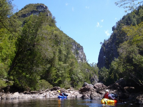
We got up early the next day knowing that we had a lot of distance to cover and were on the water by 7.00. Around 10.00 we stopped on a shingle bank mid stream in the Olegas Truchanas Huon pine reserve. We stopped and took some photos for ten minutes, but had to keep on to make distance. Shortly after that we got to Mariott’s Gorge. The river was quite low and a lot of the rapids in Mariott’s Gorge were runnable for packrafts. In fact, it seemed perfect for them with lots of 1.5 m wide chutes followed by moderate drops and friendly pools. We ran most of this section. On to Freedom’s Gates and this was mostly runnable too. Very impressive cliffs to either side of this great feature. There was a strong, hot wind blowing up the river. We passed Roslyn’s pool around 2.00, then the junction with the Maxwell an hour or two after that. This section was nice and easy going.
I was pretty intimidated by the Denison Gorge. The descriptions of the point where the river goes under a huge pile of boulders had made a big impression on me. Anyway, it was actually really fun. Andrew was having a fantastic time ahead of us checking out the rapids and running all of them as far as I can remember until we got to the crux. The ‘rapid of certain death’ was really avoidable, but did make me feel a bit queasy just looking at it and thinking about what would happen if you did get sucked into it. A lot of water powers into a very solid pile of huge boulders and the whole river vanishes for about 100 m. It took us a while to locate the portage route around this and we packed up the rafts to go over that. On the other side there is a nice rock shelf a few metres above the pool where the river re-emerges from its underground section. We re-inflated the rafts and got going again even though it was 5.30 or so. We really should have stopped there as it is a nice spot to camp. Anyway, we went on and through a really beautiful section of large boulders to weave through. We were in a hurry though and just went on as fast as we could and took no photos. It was starting to get dark. I was looking for an old hut marked as ‘Denison Camp’ at GR 697 054 but somehow I missed it. It was hard to read the landscape in the dim light. When we came to the Gordon it was a big surprise. A big, cold, dark surprise in fact. It was around 9.00 and the light was fading fast. We stuffed around trying to find campsites for a while on both banks of the river. Then after it was properly dark only Joel and I had headtorches available. I looked on one bank and he on the other. We could hear a rapid up ahead. Eventually Joel committed to climbing up a steep, muddy bank and found a spot in the forest above. We all gratefully got up there one-by-one, lifting the rafts and packs up to about 4 m above river level and stashing everything in trees. There was very little level ground, but we all found somewhere. We had a rehydrated meal and the last of the whisky. I got my tent set up on a twisted, sloping spot, got into my sleeping bag without bothering to try to arrange the remaining fragments of my sleeping mat. I found some sort of vaguely stable position on the twisted, uncomfortable slope and passed out. It was after midnight. I slept like I imagine convicts or slaves sleep.
I woke up apparently without having moved. We were all a bit tired that morning. The weather was looking like it was finally changing with the sky being overcast and some wind starting to blow up the river again. Most of us (except Andrew) found the Gordon pretty uncomfortable as we hadn’t used packrafts on big powerful rivers before. Big eddies had an unsettling way of pulling down on one side of the raft and the large-volume wave-train rapids were new to us. I just tried to follow exactly what Andrew was doing. The wind started to get amazingly strong. Gusts were powerful enough to shove you in the raft from one side of the river to the other in seconds. On Shark’s Tooth rapid, it got really gusty. Andrew had already passed it and was waiting for us. Joel and I were halfway down and got slammed to one side of the river by gusts. Klaus made it, but then just when Bruce was entering the rapid and was at the crest of a wave, a huge gust hit the underside of his raft, picked it up and flipped him over. He swam the rapid, looking calm, and Andrew retrieved his raft. It was the best swim of the trip.
It started to rain properly after that and we slogged on into the rain and nasty headwinds, hugging the banks to mitigate the wind effects. We got to Heritage Landing about 3.30. We met up with Elias from Franklin River Rafting who I’d talked to on the phone and was bringing out a group of his rafting clients on the Stormbreaker that we were also going on. He had kindly agreed to drop us back at our car in the bus he was taking his clients back to Hobart in. The car was still there when they dropped us off and we all got back home thinner, wiser, more scratched and beaten than before.
Final thoughts:
- The Denison is a great river for packrafts. The scale and remoteness suit them perfectly. It is a really lovely river.
- Don’t go in the way we did. I’d love to do it again by the normal route across Lake Gordon. You could try going from the King William range instead, but I imagine that would be hard on the vegetation front also.
- Full-length gloves, helmets, scrub pants, tough gaiters and boots, neck protection, eye protection and something to tie over your mouth so you don’t inhale tea tree scrub dust are well worthwhile for this sort of bushbashing.
Simon Jarman, May 2013.