Well, we made it out alive. Thats how we feel anyway, it wasn’t all bad but not as good as we wanted this year. S. Fork FLows at 2200 ish when we put on. West fork S. Fork Sun was under 400 cfs, probably 380.
Hiked over Stadler Pass To Danaher July 30th. Water was low but floatable. Put in about a 1/4 mile below camp creek. Full on river wide log jams x 2 in the first 5 turns. Required full deflate and inflate to get through the thick woods on either side of the river. After the 2nd one we said screw it and just packed up and headed to the confluences. The wife had had enough for the day but I would have definitly blown up and put on again lower down where the river comes right to the trail about 2.1 miles above the confluences. From there down looked low wood and good water.
S. Fork level was pretty darn good at 2200, slow and butt dragged a few time in parts but enjoyable. The always present log jam between mile 3 and 4 was an easy portage. The Burnt park “rapid”, between mile 10-11 got me. Its not really a rapid just a standing wave type thing where the two channels come back together. Last year I was able to take the left channel and it hits it head on which was easy. Low water made the right channel the main channel this year and i came into it at the wrong angle and leaned to hard and tipped into a deep pool with little consequence. Wife had no problem with it, go figure.
Just above white river between mile 13/14 the river made a hole new channel to the left. An easily portage around a river wide fallen Aspen, and then just a few hundred yards later the new channel turns tight and brushy with a tight entrance between two root balls and logs. We decided to portage this although someone with more skill could do it. Risk reward for us was not worth it. The portage was easy through the previous flood zone. Crazy how the river just moves 100yards from last year.
Had trouble finding the white river trail from the confluences. Bush wacked through blow down and new growth pine for like 300 yards. Miserable. If anyone has a trick to finding the white river trail from the confluences with the S. Fork let me know.
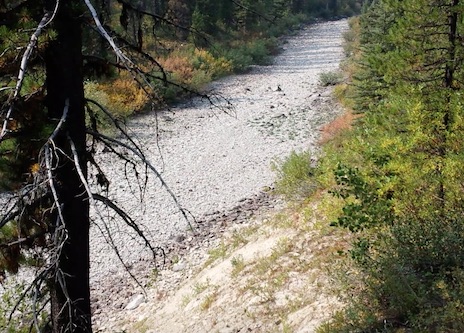
White river was very pretty but was really too low to float without constant gravel bar and low spots. We opted not to struggle with it and made the miserable hike over white river pass over the course of two days. Wasn’t sure we were gonna make it and I had to carry both packrafts just so she could. That was a tough Pass!
The W. Fork of South fork Sun river was also very low. Under 400cfs on the 4th. Every time we checked it out i could see 2 or three portages over the 1/4 mile of river we could see. I’d bet for the 4-5 miles below Ahorn creek you would portage 30 times before the packbridge. Maybe i’m wrong, but from what river we could see, what was deep enough had log jams and what didn’t have log jams was too low to float. Needed another 100cfs.
Made it out with just a few blisters and scratches and A LOT more hiking than I had wanted to do. Between not floating the Danaher and the West Sun that tacked on another 10 miles. Really wanted to float the White. Not sure i’ll get another chance at it, we’ll see. There was really no snow up high, which was unusual for this early in the year. Had we done it 10 days earlier I think the trip would have gone different.
Hellcat, don’t get me wrong. Being back in the Bob on the river is my happy place. The south fork was amazing as always!! We kinda rushed through the floating on it, unfortunately, I just tried to cram this trip into 5 days instead of 6 like originally planned. Wasn’t expecting that much hiking which was a bummer but still beautiful country and we could have easily laid over another day and not made the hiking so brutal. If i had the choice to go back in time to last weekend I would have just done the entirety of the S. Fork and eliminated the loop part at these flows. And put on Danher a little furthur down instead of just below Camp Creek. Live and Learn. New plans for next year in the works.
Also, did run into a group that put on on youngs above the canyon section, not sure how high up. They said there were two easy log portages and nothing in the canyon section, just fun rapids/boulder stuff.
After digesting your report some more (and getting the kids to bed) I realized that I’m just jealous.
My first year (late Aug 2017) the rivers (S.F. & M.F.) were nearly dry. My second year (late June 2018) the rivers were like riding a bull. I was hoping this year (19th July) was going to the epic ‘perfect timing’. So I realized it’s going to be a little low this year and I’m just jealous. Just got my fingers crossed that there are no forest fires between now and then.
We were there just a few days before your trip. We did about 4+ miles of Danaher, and I only recall portaging logjams twice. Unfortunately, one of those was just about 100 yards around a sharp turn after we put in…
We didn’t deflate for those portages, but we had to detach our packs and shuttle gear through the forest.
The other two people in my group flipped at that point I think you describe just above the confluence with the White. They rammed into the logs on river left as they entered the S curve. I was in the back of the group and decided I didn’t want any part of that, so I managed to get through with just some aggressive paddling.
We pulled out at Helen Creek and did lots of hiking over Pagoda Mountain and Larch Hill. There was a trail crew working on Larch Hill, but we passed them, and that was a terrible ascent through hundreds of blow downs. It should be clear by now, though.
It was an amazing trip, and it sounds like we were just in front of you by a few days.
Thanks for the trip report! Great info thanks for the tidbit on Youngs creek and the gorge. Does anyone know the class of water on the gorge? I thought i heard somewhere it was IV but i saw a video that looked more like lower class III?
As far as getting to the white river trail, do i understand correctly you passed the confluence then went river right to find the trail, rather than pulling off before and hoofing if through white river park? I wonder if that may be an option? With your report the white it sounds like if we plan to see the Chinese wall we wont be able to boat back down the white and cut down our hiking mileage. Was it your original plan to hike up float it and hike up again and over the pass? or am i missing something?
The trail actually stays pretty far away from the White when you go north from the trail from Pagoda Mountain. We rolled into the valley really late at night, and we couldn’t even find the White, so we ended up pulling water from a mucky old beaver pond. The next day we headed north and ran into the White about a mile up trail. We dumped all of our beaver water and filled up. The White was a perfect source of water at that point.
The trail crossed the White once or twice over the course of a mile or so, but then veered away from the White, and I don’t think we saw it again for the rest of the trip. There was a tributary stream about 1/4 mile west of the trail just before the climb up to Larch Hill with a high use outfitter trail heading to it. That’s where we loaded up for the hike over Larch Hill.
We were really surprised that the trail stayed so far away from the White through that valley.
We could have done Danaher without total deflated but out of frustration we did. Over reacted I’m sure
Yes, we floated to the White Confluence and hiked up river right. I thought about finding it at white river park but didn’t want to re inflate once we found it to get to the west side trail. I don’t know much about the east side trail though I suppose we could have just stayed on it.
Ya , our plan was to hike and float white back to camp one day and then up over white pass but started a day late and had to give that idea up unfortunately.
Everything i’ve Ever heard about Young’s gorge is classII-III
The group I ran into didn’t make much of it. I will try it one of these days.
Good to hear. I was up there in 2017 and it was completely dried out. Nothing but dried white rocks above Needle Falls, even the pond was nothing but muck. I was expecting to re-hydrate but I was forced to do a dash up to the Wall and quickly return the 8 miles back down ‘dry’. It was miserable. I skipped the Wall on my South Fork trip last year because of the weather but I’m hoping to get my chance to loop the Wall this year.
Thanks for the data! sounds like we will likely run the youngs gorge…wife’s approval pending, but we may have to put off the china wall for another trip if boating back is not an option. I don’t think she will be happy with a 20 mile day hike. Although…its our 20th anniversary, so the numbers add up! lol
Boy, it never occurred to me that there might not be any water at the headwaters of the White. I’m glad we didn’t hit it when it was dry. It’s crazy how much that changes…we were wading the White near Brushy Park in water up to our knees.
We saw more grizzly tracks on Pagoda Mountain than anywhere else on the trip. One set of those tracks had me questioning my doubts about the existence of sasquatch. But we didn’t see a single bear on the 10 day trip.
Crazy. Didn’t know the N White would go dry. I floated the north fork of the White from Brushy Park to Needle Falls last summer in early July, but 2018 was a big snow year. Not sure if it had ever been done… so I wanted to check it out. To my surprise, the flows were decent, minimal logs, some cool gorges and boulder fields. Caught fish up there too… they must survive in pools somewhere when it dries out!?
Just got out on 8/12 from our 2019 Bob trip. Flew to Benchmark from Kalispell on 8/6. Hiked Stadler to Basin Creek Cabin. Floated 6 miles of the Danaher… was super low, quite a bit of dragging, but fishing was good. SF floated well. Was informed at Big Prairie that the river below Salmon Forks was closed due to fire. When we got there, we hiked up the Big Salmon drainage to Pendent Pass to Holland Lake. ~45 miles of hiking, ~30 miles of floating, insane fishing. Hardest of 5 annual trips thus far, but the most memorable for sure.