The first packraft on the River Tua !
Well it is a claim I’m sticking to as according to the PNG 1:100,000 map sheets the infamous Tua starts from the point where the Asaro and Fenagufu Rivers meet and I travelled at least 800 meters past that point.
Over the last year I have been floating around on the Asaro and Bena Rivers of the Eastern Highlands, starting first in the company of my colleagues on inner tubes before moving on to the Supai Canyon Flatwater II and now an Aire BAKraft. In reading this report, it is worth bearing in-mind I have never tried the more traditional design of raft as seen with the Alpackas so cannot draw any conclusions as to the relative merits of either.
The major outstanding piece of river to be completed was the final downriver stretch of the Asaro to the point it meets the Tua. It was a stretch that made me nervous thinking about it as it takes the river out of the flat alluvial plains and cuts through the hills for its final kilometers. While on reaching the Tua there is an obvious exit point where a footbridge spans the river a look on Google Earth shows that not far past that point the gorges and fierce or deadly rapids of the Tua begin in earnest.
Launch: 6 11 24S 145 24 32E
Exit: 6 14 58 S 145 23 46 E
Certainly from both the map (which shows a wide blue line changing into more of a thin blue pencil line) and looking on Google Earth (and similar) I knew that the river became far narrower and I also identified a number of rapids with a single particularly fierce looking one (6 14 27 S 145 24 20E). While travelling by inner tube is fun and quite good even over waves the tube suffers from the disadvantage of lack of maneuverability and within a fast moving river it can take some time to reach the shore or a safe spot. With this in mind I decided to go alone using the BAKraft rather than as a mixed flotilla. Having completed the trip this was the right decision.
The Asaro is a river that always seems a bit intimidating as it is a fast river. Even now, after little or no rain for some weeks and with the river is at its lowest and slowest levels the words of a local saying go through my head: “when the people are hungry so is the river”.
This was going to be my third outing with the BAKraft and on the whole I have found it to be a good boat which inspires confidence. The comments about the ISC (Inflation – Seat – Cargo Bag) and the awkward way of inflating the raft as made by Chris S of the apaddlleinmypack blog are really true. The ISC is a failure, heavy and hard to use as an inflation bag (although livable with) and terrible as a seatback as it looses air. The consequence of loosing air is you lean further and further back which is OK except that I found when caught by an eddy this exasperates a tendency of the boat to sink at the aft which then results in less of the length of the boat being in contact with the water so making it less stable. Certainly I will be buying an inflatable seat bag and lightweight inflation bag from Baylee and a K-Pump Mini.
Chris S also mentions the increased weight and packed size of the BAKraft and while I’m sure in this he is also correct I have not so far been unduly concerned over this penalty. In order to compensate for this there is a need to minimize and / or lighten other gear but being in the tropics or higher altitude tropics I can get away without dry suits and warmer / heavier clothes and camping gear.
For this trip I brought aside of course from the raft and four piece paddle a helmet, lifejacket, wetsuit vest, hiking pole / clothes and some safety equipment. The other major weight was three liters of water (insufficient given the walking component in the midday heat). All of this except for the wetsuit top, helmet and life jacket fitted in the backpack (Six Moon Designs Flight 30). In anticipation of the possible need to hike out after loosing my raft I wore trail runners the whole time. I didn’t need the wetsuit top but felt if I ended up being swept down river or stranded overnight I might need every bit of protection possible.
I know when I read some of the other reports on this forum that my little excursion was just that, a little excursion ! But at the same time I needed to prepare for the worst and in the hilly country even walking out would be at the least hard work.
So with some trepidation I started my trip on the wide river of the flat Goroka Valley – the river levels were as mentioned very low and the water barely moving so for the first three km or so I had to paddle with little assistance from the current. The day was beautiful as the sun was not yet too hot but as the river seemed to ever increasingly point to a range of hills I also fully realized that the map and Google Earth were not lying and the river was indeed going to change. But before that, and due to the slow inflation process of the BAKraft I first had to stop and add extra air into the tubes and flooring. This would also be one of a number of stops in order to re-inflate ISC bag. It was at this point I discovered my GPS – with the carefully listed points marking the rapids – was almost out of power. Like an idiot while I had checked the batteries the night before I had foolishly accepted the full charge showing even though I knew I had used the same batteries on the previous two trips… I think Homer Simpson has a word for this. Even more of an idiot, while I had put spare batteries out I had, in the cause of saving weight, left them behind. Benefiting from my numerous examinations of the route on Google Earth I was confident on the rough locations of these possible hazards and so turned the GPS off to conserve its power for the stretch before the major rapid which I most certainly wanted to stop well clear of.
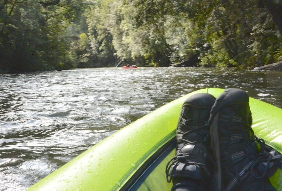
As the river narrowed and speeded up the raft easily handled the various sections of whitewater, waves and eddies. It was maneuverable when needed and the power from the paddle allowed me to choose where I wanted to go and not be at the mercy of the currents. Just before this point I passed a couple of ladies doing their laundry who gave warnings of the danger ahead and so to ease their fears I promised I was walking back to the highway from just around the next bend. With this little lie behind me I continued my trip although where necessary I scouted some sections – I think I heard on one of the Alpacka Instructional Videos the advice ‘never go down something which you haven’t seen’ so that was my guide to when I needed to step ashore and look.
That humans did come down to these sections of the river was apparent from the occasional fish trap and the odd glimpse of paths but it was only at a major bend in the river did I come across a group of fishermen. As I approached I called out so as to not surprise them and received, along with the surprise, some friendly greetings. Then it was on and the next stop was the distinctive rapid I had seen on Google Earth.
My experience at this rapid was, apart from the major plus fact that I successfully stopped before it, a good lesson on ways not to manage a portage. To begin with, inline with the mental image of the stop, I landed on the right hand bank instead of the left despite the left having an altogether more hospitable riverbank as well as a good view of the whole rapid. Then, due no doubt to the adrenalin, I then immediately clambered up the steep high riverbank lugging the ISC, paddle and fully inflated raft. With some difficulty I got the top of the steep part and putting the paddle to one side tried to pull the raft up the final 10 feet but failed and so admitting defeat returned back to river level … only to discover I had left the paddle up the top and had to climb back to get it. Once that was completed I started walking upriver to give myself a big safety margin for crossing the river. Now, if I had investigated options before I would have discovered that there was just 20 meters up stream a semi path (steep but recognizable scramble) so saving considerable time and energy. Lugging everything up was still hard work and even following a small path to the end of the rapid sapped my energy as the sun was burning and my failure to spend two minutes dismantling the paddle and putting it and the ISC in my backpack was costing me dear in extra physical effort.
Relaxing for five minutes I gulped down water before heading back onto the river. Foolishly I did not try and clamber over the rocks to get a better look at the rapid but maybe it was common sense as the rocks were in one part quite steep, I was tired and the river didn’t look like one you wanted to fall into. When I look at my photos it seems tame but in real life the rapid is far more fearsome and looking up at it there is quite a drop in height over its short distance.
After this it was on the home straight and shortly on meeting the Fenagufu River I was onto the Tua and then the footbridge and the end of my paddle. The trip had taken about 3 hours of which about 1hr 20mins were ashore (one hour on that single portage) and a total distance of about 13kms. This has the 13kms completed in around about 1hr 40minutes so just under 8km/hr, but taking out the first 3km where there was barely any current it is likely that for much of the time my speed was closer to 10km/hr.
After a leisurely packing up of the raft I then followed a clearly defined path for an hour to a graded road and then eventually a main road and after an hour wait a PMV Truck (the equivalent of a bus). While walking I passed a few locals who all greeted me warmly and were, like the small crowd who waited with me for the PMV, very interested to hear the story of my travels and the liklik (small) boat in my pack.
Attached in the link are some photos of the trip in sequence:
http://s1113.photobucket.com/user/el_fireball/library/BAKraft%20Tua%20Asaro%20Rivers?sort=9&page=1
