Another Colo River trip, NSW

ROUTE: Walk in to Colo River via Canoe Creek, paddle downstream to exit at Bob Turners Track. (Maps: Colo Heights for the first 90%, Mountain Lagoon for the last 10%)

DATE: April 23-25, 2011

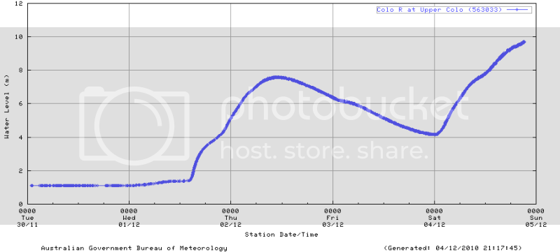
CONDITIONS: BOM gauge at Upper Colo reading 0.95m on Apr 23, falling to 0.93m on Apr 25. Weather generally overcast and drizzling


DAY 1: I had the luxury of time: four days with no work or family commitments. I’d had this trip in mind for a while, and was a feeling a bit of trepidation about it – it’s a pretty remote area – but this was the ideal opportunity. After borrowing an epirb from Windsor Police Station I parked my car at the end of Grassy Hill Firetrail, off Putty Road, and got going just after 1pm – a bit later than I’d been hoping for. The walk in is steep and strenuous but not too long, about 1hr 20 mins. Colo Gorge was filled with a thin mist as Savage Ridge came into view. Started paddling at around 3pm – leaving me just over 2 hours before daylight ran out. Didn’t fancy trying the first few sets of rapids so progress was pretty slow… made about 4km before striking camp on a sandbank below some rapids. Hit the sack at about 6.30pm – first time I’d done that since I was about eight, I reckon – and fell asleep to the constant crash of whitewater.

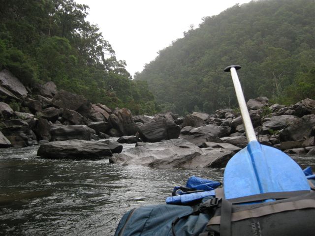
DAY 2: Thick mist hugging the tops of the cliffs at dawn, beautiful. Got going at about 7.15am. The morning soon developed its own routine: paddling along tranquil pools, taking in the scenery and listening to the calls of Bellbirds and Eastern Whipbirds coming from the forest, then the hiss of approaching rapids. Most of these rapids I didn’t attempt to paddle; I just hopped out of the boat and kept a good hold of it as I waded along the side of the river (I was wearing a wetsuit, and walking shoes for ankle support, which was definitely a good idea for doing this). The rapids were all pretty short – about 40m at most, I reckon – and easily bypassed in this way. (With the river this low I’m not sure how many of the rapids would have been feasible to paddle, anyhow, even if I’d wanted to; you’d certainly be bottoming out a lot.) I tried to paddle a couple of the easier looking ones but even on these I was out of my depth – kept bouncing off boulders, going down backwards, getting beached on just-submerged rocks…. felt like a trailer for Laurel & Hardy Go Packrafting. I could see that the key is anticipation – putting in the paddle strokes early – but even when I tried doing this I had the uncanny knack of hitting the very obstacles I was trying to avoid, as if I were drawn to them by some invisible force. Never mind… I didn’t want a white-knuckle ride anyway, I just wanted to experience the Colo Gorge.
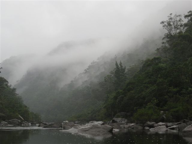
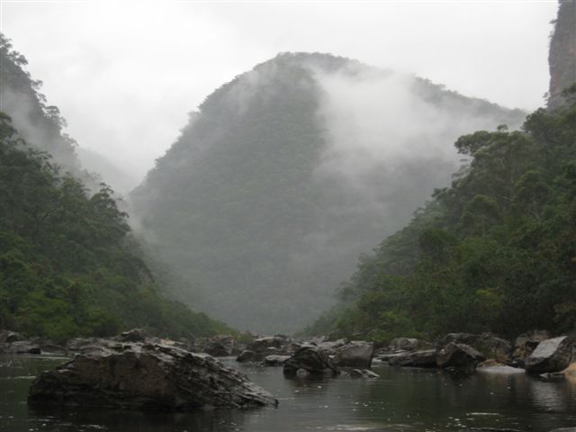
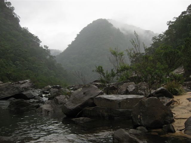
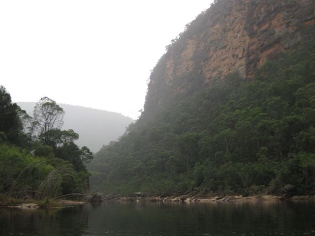
And I wasn’t disappointed. This place is incredible. As the morning went on the cliffs on either side grew bigger and more impressive. With its towering red sandstone walls and thick forest it looks more like something out of the Northern Territory than a couple of hours outside of Sydney. (Unfortunately my camera started playing up, giving me Memory Card Error prompts, and the only way I could clear it was formatting the memory card that night….so the only photos I’ve got, below, were taken from the Wollangambe Junction onwards. A bit of a bugger)
I stopped for a late breakfast below the rapids at Main Creek, then reached the Wollangambe at 2pm. I had intended to push on further before striking camp but as soon as I saw this spot I thought, this’ll do me. (Found a nice flat spot for my tent next to a giant boulder into which someone had hacked “Wallangmbe 1943”. I know you shouldn’t judge previous generations by the standards of today, but really, what a vandal, and an illiterate twat to boot). Opposite were mighty cliffs, 200m high, catching the rays of the afternoon soon which was just breaking through the clouds for the first time on this trip. The Wollangambe looks like a lovely river; little fish were sitting in its inflow, sending out concentric ripples as they sipped food off the surface. I went out with my rod and a surface lure to try to tempt their bigger brothers; no luck though. At dusk the big cliffs opposite caught the last of the sun, turning deep red. Hit the sack at 7.15pm – thought I’d have a late one.

DAY 3: Grey, overcast morning. Packing up gear that’s wet from condensation on a sandy campsite not much fun. Got going at 7.30am. At the first set of rapids below the big pool at the Wollangambe junction I really noticed the extra volume of water, and its power. Picked my way carefully through the boulders, dragging my boat over them where necessary (it had picked up only a few scuffs on the bottom by the end of this trip, amazing really considering the amount of dragging and bouncing over rocks it did). I had a go at paddling the next rapids, and as I spilled out at the end I saw that my clumsy efforts had been witnessed by a solitary bloke on the riverbank. I paddled over to say hi. Nick had hiked in via the Drip Rock Firetrail and taken a pass which dropped him about a kilometre north of the Wollangambe junction (he was using the Anthony Dunk book, and described the route as “pretty sketchy”). After a good chat I pushed on. It was drizzling with rain and a thin mist was hugging the forest high above the riverbank – a beautiful sight. After about 3.5km I reached a long, long pool, at the end of which was a short but very steep set of rapids filled with giant boulders; I think this was the “King Rapids”. The boulders here were super slippy and I took a nasty fall while portaging; nothing broken thankfully. Then there were another few sets of rapids below this to overcome… by this time I was getting pretty exhausted by all the carrying and dragging. Then a long, final pool brought me to the exit point at the Bob Turners Track at about 1.20pm. As I was packing up a rescue helicopter appeared and flew up the gorge, before returning ten minutes later and going towards Colo Heights… hope they were alright.
I underestimated the amount of time it would take me to reach my car from here…I hadn’t counted on feeling quite so shagged at this stage! The climb-out along the Bob Turners Track was about an hour, then I picked up my bike – which I’d stashed in the bushes at the end of the firetrail – and cycled the 28km back to my car at the end of the Grassy Hill Firetrail. That took me about three hours; I was ready to drop by the time I reached the car.
A terrific little adventure in an amazing part of the world. Thanks for all the advice people have put on this forum, it stood me in good stead. Some pics here of the Wollangambe junction, and downstream, from the morning of day 3.
COLO trip 2 030.jpg
COLO trip 2 035.jpg
COLO trip 2 031.jpg
COLO trip 2 012.jpg
COLO trip 2 003.jpg

Well done Ross! Thumbs up for the paddle too, tough going with one of those badboys!

Great trip report Ross, sounds like a fab trip.

Steve

Thanks guys… I found that canoe paddle in the rapids by Main Creek, and thought I’d better take it out. I don’t know how old it was, but it was really heavy and scuffed up

Another bit of info I should have added to the trip report is the state of Grassy Hill Firetrail… a few of the things I read online suggested it would be heavily rutted and difficult to negotiate in a 2WD. There must have been some work done to the firetrail since those things were written, because I found it passable in my Mazda 3 (a fairly low-slung 2WD), even in the rain. As long as you take it slow and pick your line through the rough bits

cheers
Ross

Hi Ross,
It was definitely very unexpected to bump into someone in such a remote area. Good to hear that it all went to plan and sounds like a great trip. I saw that helicopter too and glad to hear it wasn’t for you! That cycle ride must have been tough at the end of such a long trip; perhaps you could do it at the start of the trip next time? Is that possible?

Rest of my trip (sorry if it’s too long!):

After seeing you I hiked 2.5km downstream and then headed up the tributary on the left as planned. After 45 minutes or so I reached the “dry waterfall” detailed in Anthony Dunk’s book. It turns out that although physically climbable it’s very very slippery when it’s wet (it may as well have been ice quite frankly). I took one slip near the bottom and flew 3 feet off a ledge and landed on my side, luckily uninjured. After that happened, I aborted climbing the dry waterfall; a fall there would mean a serious injury or worse. There seemed to be no other way round in the vicinity, so, after a fairly bleak moment realising the enormity of what I now had to do, I reluctantly hiked back down to the Colo over the extremely arduous and dodgy terrain (overgrown plant-life and slippery boulders of huge variation in size similar to the sides of the Colo). When I reached the river again, I gritted my teeth and headed downstream to Bob Turner’s track 10 kms or so away, grimly knowing how tough and long it would be.

Totally soaked through to the bone (as I was for the rest of the trip), I hiked a steady but cautious pace knowing how serious a fall / injury there would be; hacking through the bush and climbing over randomly sized, very slippery boulders in my tough yet seemingly clumsy / slippery hiking boots (not the best option of footwear for that terrain; a wetsuit boot would have been better). Three sections of the river were cliffs or too heavily overgrown to pass so I had to put my pack in a bin liner and swim downstream. The bin liner didn’t really work so my pack became twice as heavy and everything very wet (if it wasn’t already). I spent one more night on the river on a small patch of sand I found, sleeping in a very wet sleeping bag. A poor night’s sleep; my mind playing out different scenarios of doom, trying to work out what the hell I’d do if the water level rose or there was some kind of mini-flash flood.

At first light I packed my things eager to get out of there and hiked 2 more km to Bob Turner’s track giving a small cheer when I arrived. An absolute dream being able to walk on an actual path even if it was uphill. The remaining hike out of the fire trail and then 5 kms up north on the bitumen was fairly painless in comparison to what I’d already been through.

On reaching the car, I sighed my relief and changed into my clean clothes discarding my soaking wet boots, trousers and top with glee. However, when I headed back out towards the road my car couldn’t make it up a steep section of the fire trail. Putty road was tantalisingly close (30 metres away) yet the VW golf was stuck. The combination of the small river that had started to flow down the centre of the fire trail and the clay-like surface rendered the wheels virtually useless; they pointlessly spun as I desperately tried to gain traction. A very tedious scenario when you’re tired after 3 days of tough hiking. I had to stick on my trainers and get hiking again to find help. The 3rd farmer I got to managed to help me get out but not before 3 hours lost and $500 worth of damage to the car!

Although, a tough trip, it was very rewarding to have completed it safely and was proud of my mini-adventure; so much better than than sitting at home on the couch…

CONCLUSION: buy a packraft!

Nicholas

Sounds like a great adventure but stay safe out there, buy a packraft and a PLB. The rafts have their own dangers but can make travel in such country pretty straight forward, they open up a whole other world for adventure travels.

Steve

Thanks Steve; good advice. I always take a PLB (but hopefully I’ll never need it!) and I always aim to mitigate any unnecessary risk as far as possible. I think flash floods would be the biggest likely concern in a place like the Colo so it’s important to keep a close eye on the weather beforehand. It was clear that there had been some seriously high flooding reasonably recently (probably in December or January this year); perhaps 10 metres or so above the current level judging by the landscape and shape of the vegetation on the banks.
PS. wouldn’t recommend hiking down to the Colo from Drip Rock Fire Trail unless you have pretty good navigational skills and you’re keen on hacking through some serious undergrowth (definitely not ideal carrying a packraft).

You’re right Nicholas, the river hit around 10m in early December. I saw the same evidence you described in January when I came through…debris high up in the trees etc.
When the river was up I paddled the lower section at 7.5m from Upper Colo to the Putty bridge. I would hate to have been upstream at the time! As you mentioned though, if you watch the weather a week prior you will know what to expect.
High water Colo fun - Darren M: High water Colo trip

This is what the Upper Colo gauge did during the December flood…

Hey Nick
You’ll be laughing about it in years to come … definitely a ‘character-building’ trip you had there. I was looking at the banks on the final day and thinking how awful it would be to have to walk it. I think you did pretty well to do it in the time you did.

Sounds like you ought to get yourself a packraft! This is a good time to buy, with the Aussie dollar being so strong. I’ve only done two trips but I love it already… I find myself looking at maps in a different way. I am really keen to do the section of the Colo north of Canoe Creek (starting at the Crawfords Lookout drop-in that you were talking about)

Stay in touch… I’m always up for a bushwalk or a paddle when I can get some time off. Mobile is 0410 203060

Cheers
Ross

Nice trip Darren! Should imagine it would take some balls to do that; fast flowing and lots of unknowns?

Definitely stay in touch Ross; let me know when you go on your next trip. My mobile: 0449 600 193.