Hi
A couple of NZ traverses for your viewing/reading pleasure
Landsborough river
Back in February this year Matt, Scott and I did the classic Landsborough river via Broderick pass trip.
This was a bit of a dream trip for me as I’d first thought about a packraft style trip almost thirty years back as a young climber hanging around Mt Cook, when the Alpacka raft caper was still a twinkle in Sheri Tingey’s eye. I had starting writing a trip report but it was getting way too self indulgent so I will save that for the blog I always threaten to start (but never do) so some observations instead:
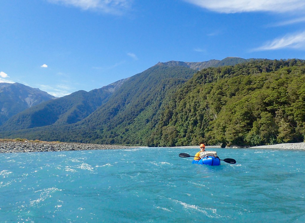
It certainly is a classic trip, for mine the exact thing that you are looking for as a packrafter. A wonderful walk over an alpine pass into a (relatively) remote valley with floating out being the most viable option, with some fantastic whitewater to boot. And the scenery … I’ve done plenty of NZ tramps and climbs but this trip is certainly on the podium for views
Access: being a traverse not a loop presents a few problems. The trip starts in the Hopkins valley past Lake Oahu and comes out on the west coast highway near Haast pass. The shuttle is massive and takes a day but is a mostly pleasant drive. We were time poor so forked out for two rentals, it was worth it for us as it also came in handy chasing weather and water for the remaining week we were over for. If you have time certainly hitching from the end would be OK but getting into the trail head would be a little more difficult, sourcing a sympathetic local may work (we looked into a drop off company but couldn’t find one for this trip)
Time: up to you, think it can be done in three days; we took 4 and a half as we were held up going over Broderick Pass.
The walk: very nice walking firstly up the Hopkins and Huxley valleys and over Broderick Pass to the Landbsorough at Creswicke Flat. Most groups then walk up to Kea Flat and float back to Creswicke before heading out. The walking is reasonably well marked although no Milford track, it was similar to lesser used Australian walks in the harder bits (marking wise). To Broderick pass is well marked with tags and poles whilst the way down is tougher going still marked with cairns and tags. It’s very steep down the final spur, and slippery as well! We only got ‘off track’ once near the bottom in a vertical fern maze (big thanks John M for the track notes) Think this is mostly done in two long days
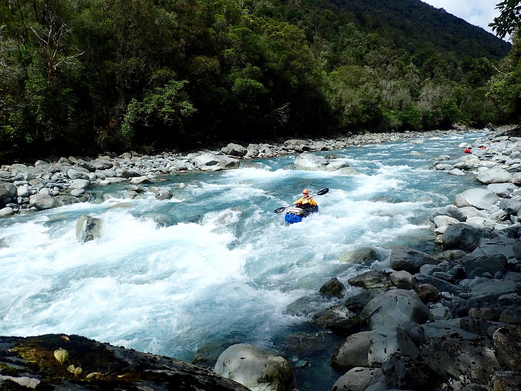
The paddle: the paddling is mostly in that grade 2+ area I’m guessing, lots of really lovely long races at that standard. The harder section in the Upper Gates gorge is short, maybe 300m and has about 4 solid rapids in it. It was easily portagable on river left. We had a slight disaster as after the first rapid Matt fell out getting into his boat and it floated off through the gorge. Scott and I reluctantly portaged two rapids (a nice one ending in a drop and a short boulder choke) before Matt reappeared with his boat. I jumped in and ran the rest of the gorge and it felt pretty hard (sorry no pics except of the first and last drop given the snafu). Below there were many good rapids, some getting close to the gorge standard but all portagable at the level we had (running a stunning blue) I believe its death in high flows and a nightmare walk around. The last few kms are easy floating in a stunning location . We found campsites about 3 hours from the end of the trip near Harpers Bluff and did a 11 hour day from Fords to here including walk up
Overall: I would suggest that you wait for a good forecast ! This was my third trip over (albeit only a week each time on the previous trips) and the only time I got the right weather, as it was we had a two day window but it was perfect. It did feel pretty committing as you are at the mercy of the weather really. We ran from Fords Flat to well below the Upper gates in a day to ensure we got below the nasty stuff in the event the weather turned. We were happy it didn’t !
I wouldn’t take this one lightly, although I’m over fifty and was unfit and carrying an injury on this particular trip (appendix removal a few weeks out then calf injury in a foolish and desperate attempt to get fit … all in the non existent blog) I felt I’d done enough paddling and tramping to make good calls and had sensible and experienced companions. Having said that I think one of the guys with Roman Dial on the inaugural trip had never packrafted before … your call
Hot tip: admittedly I didn’t research beyond the known trip, if it’s good enough for legends etc. But having said that the T shaped nature of the trip is a little unaesthetic! I heard and have since read that you can get into the Lansborough over Elcho pass further up the Hopkins. This will bring you out right at Kea flat. Maybe a new classic ? … I’ll leave that for others to explore !
Pics and vid snippets at:
Taipo
I’d seen Roman Dials video of an in out trip on the lower Taipo river … it looked really good providing not too extreme paddling. In my obsession with traverses I noted that you could access the Taipo via Harman Pass as part of a classic tramping circuit. Sounded great to me
I’d put this one on the back burner as it was more of a walk than paddle but it came roaring back into contention when we got a three day weather window at the end of our trip. Unfortunately Matt had a flight home a couple of days prior to Scott and I. Scott was as keen for a walk as a paddle so it seemed like a good option.
The trip started from Klondyke corner just before Arthurs Pass, less than two hours out of Christchurch and would finish at the bridge over the Taipo on the same road a couple of hours further on (and down through the spectacular Otira river gorge)
The first day was a casual 5 hours or so up the Waimakariri river to the large Carrington hut with a number of easy river fording’s (and the low heights we had) There are some speccy views up side valleys particularly towards Mt Rolleston to the west.
Day two follows the Harman Pass route firstly up the Taipoiti river gorge. It’s pretty enclosed and plenty of uphill but quite gorgeous in here. We reached the pass in low cloud but were able to follow the snow poles down into Marys creek without problem. It was a long boulder hop and then nice valley walking to Julia hut. All in all it was about 7 hours walking and I was pretty boxed at the end of the day. But again a superb days waking
It is possible to paddle from Julia Hut if you’re good enough, think its continuous grade 4 with some harder bits !, you need more water than we had We were happy enough to walk a further two hours to just below the swing bridge above Mid Taipo hut.
From here it was about a 5 hours paddling to the road. The water level was a touch low at the put in but was only noticeable in the few sections were the river divided. We were able to paddle everything with the exception of one very rocky initial drop in one of the rapids. I’m not much of a grader for pack rafts but the upper third or so was characterized by short sharp rapids or longer boulder garden type thing maybe getting on grade 3 in parts ? The lower two thirds was more very long races and easier rapids, still grade 2ish I would say with potential for some very long swims indeed, the gradient just keeps up. All in all a superb intermediate run and a nice finish to the walk. The last km or so in a spectacular little gorge, kind of intimidating as you can’t see what’s coming but it was all good at the heights we had. We pulled our river left just above the road bridge
The visual gauge at the bridge at the take out was 2.3m , I think in Romans’ video it was 2.4m or so. Anyway it was enough. It would be a different kettle of fish at high flows given the gradient and length of the rapids
Overall we felt this was a very worthwhile trip, more walking than paddling but both were really nice. It would be easy enough to hitch this trip or do with one car as the access is off the main road. You could also easily do it as an in and out trip (two days) but check track conditions with DOCs Arthurs Pass as there was a washout down low making life hard for walkers . As traverses go its a good one
Unfortunately my Olympus Tough camera had conniptions half was through this trip so I missed photos of most of the pretty and harder rapids. It was only near the end I remembered I carried an old camera for such events. The crappy videos are the product of this camera… but it gives an idea of the gradient etc. Enjoy
Thanks Matt and Scott for a really fine time
Cheers, Mick

