We ran the South Fork of ER on Saturday and had a blast. Lots of twists and turns make the SoFo feel like a Le Mans track with the pedal down. The Amazing and durable Alpacka rafts are the perfect boat for this type of narrow obstacle filled water. I almost swam when high centered on a boulder, but thankfully my sprayskirt held firm under pouring water and was able to pivot around. Thank you John N for clearing out some of the wood, and Ben King for knowing where the hazards are. The Ship Creek gauge was at 5.15.
Hey Brad- Ship’s at 5.3, how’s the South Fork looking? Any new wood visible?
I’d like to run it this weekend if it’s good. I could drop off those new Alpacka poles for you 
It is looking pretty low to me John. I boated it last year with you and Patrick if you recall.
Of course I remember, how’s your Vanagon doing?
I figured this was a little early, but with Ship running high I was being hopeful. Let me know if it comes up and if you want to run it again.
South Fork looks to be really pumping right now with all of this rain!
Ran the upper and middle section of south fork today, USGS on ship creek had the river at 6.1. The upper has the perfect amount of water. Lots of continous class III water. The middle was also fun, no real wood in the river.
A Cautionary Tale
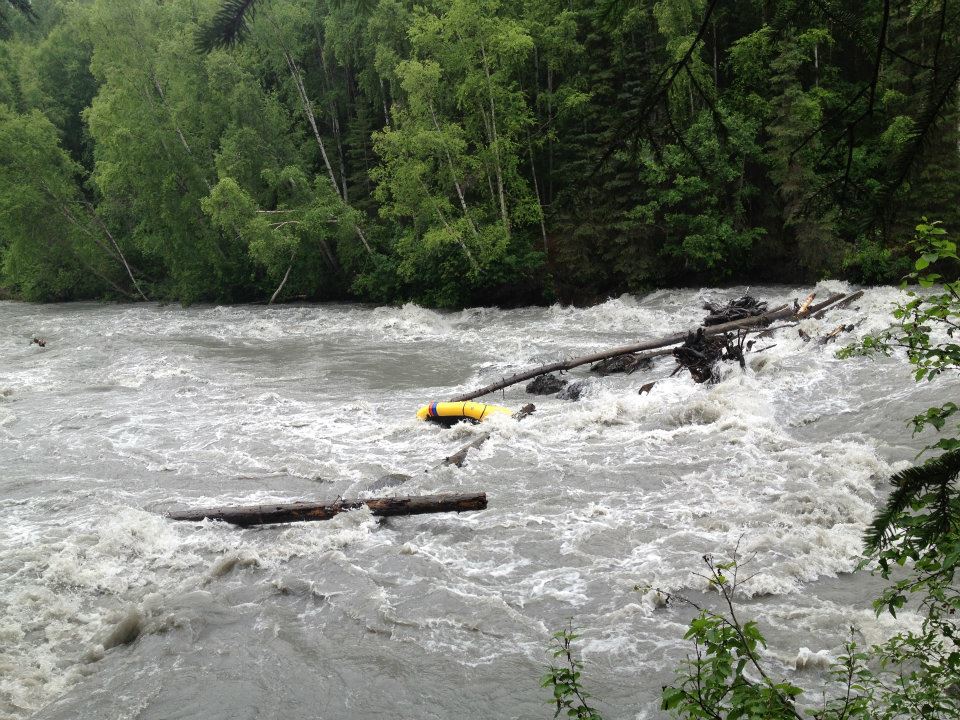
A couple of my friends and I bought packrafts recently, and are trying to learn. Learning is good. Learning is fun. We learned a very hard lesson on Sunday, though, under the harsh, cold tutelage of Eagle River. We learned about heeding warnings, when it is prudent to scout a section, and we learned about checking water levels and what those levels mean relative to our low skill level. Let me tell you about it:
First, the water conditions per NOAA: 5.53 ft. and 2.66 kcfs at the time we got in the water. High water, according to Tim Johnson’s “Alaska Whitewater”, is anything above 1,700 cfs. Mistake number one: not checking water conditions beforehand. We put in at the Eagle River Loop bridge, and were immediately thrilled to be in moving water with some action, as our most ambitious float to date was the city section of Campbell Creek. Another boater at the put-in told us to, at the very least, scout the rapids, which we fully intended to do. I asked him how long it would take to get from the bridge to the portage spot, and he said 30 minutes. At ten minutes on the water, we came to the “Canoes get out!” sign, and assumed that this was a smaller, more minor section, and that there would be more signage that would tell us where Campground is, and that since the sign specified canoes, it did not apply to us. We foolishly pressed on. Mistake number two: not heeding signs and scouting an obviously dangerous section. We got tossed right above Campground Rapids. We floated into the rapids pretty quickly. My friend Sean got out before the rapids, and my friend Topher shot the rapids without a boat. I hit a log jam, my foot got stuck, but I managed to stand up. I was standing there for a while, getting tired and cold, with no obvious way to free myself. I decided to try to pull my foot out of place so I could slither it out from between the logs. I pulled and pulled, but breaking your own ankle isn’t quite as easy as it sounds, I guess. Eventually I twisted my foot just so, and got free of the logs. I shimmied out on a log that was pointed at the bank that I wanted to go to, sat there for a second to compose myself, then jumped in and swam for my life to shore.
Fortunately, a friendly lady camper was standing there filming the rapids at precisely the time when we three fools came floating through. She quit filming and called emergency services. Everybody was out of the water by the time the fire department arrived. We got a well-deserved lecture on scouting water, and generally refraining from being idiots.
My boat was stuck on a log in the middle of the river by a stern grab line, with no apparent way to get it out. Tied to my boat was a dry bag containing my wallet, keys, and phone. We tried a bunch of things…throwing a rope to it, throwing rocks at it, dislodging the log…nothing worked. Eventually a large floating log came down the river and smashed the stationary log out of place, freeing my boat. We sprinted along the river bank, hoping to catch the boat near the shore, but it stayed pretty much in the dead center of the river for as long as we could see it. It bobbed, upside-down, around the bend and out of sight.
We decided to go down river to see if we could find it. It wasn’t anywhere that was accessible to us, so we gave up, hoping for the best. Topher had apparently talked to somebody named Ed at the campground while we were standing there confused, wet, and defeated, trying to figure out how to retrieve my boat. Ed had also lost a boat in the river, and happened to be searching for it. He had an airplane at his disposal, and searched for it that way. He found my rig, found a phone number in my wallet, and called it. That number belonged to somebody with whom I had gone to basic training, but lived in Georgia. Ed recognized the name because he happened to have gone to high school in Chugiak with this friend. I got my wallet back yesterday, and am getting my boat today. Topher’s boat is spinning around in an eddy in Knik Arm right now, though Ed tells me that he has some friends who are Blackhawk pilots on Ft. Richardson, and they’re going to retrieve it today during a training run.
At the end of the day, we were all pretty lucky to be alive. We learned some very important lessons, that are very difficult to learn from a book, and gained a kind of respect for the river that we will never forget.
The South Fork has been running high the last week and two of us ran two sections of it on 6/26/12. The upper section above the trail foot bridge is outstanding splashy fun at these levels. This is my favorite section because it is so fun to paddle above treeline. I would recommend this stretch for anyone except novice boaters.
The first mile below the trail foot bridge is also good, although more wood starts to appear in the creek as you enter the trees. Some clean-up of creek side wood improve this section, in particular a spiky tree that juts out from an island that splits the current. You can go either way around this island, and at higher flows it is easier and safer to go river left around the small island.
Downstream of the second bridge (a red driveway bridge that can be ducked by putting your face on your deck) the creek gets crazier and more wood appears. At these higher flows pulling over river left to portage the first foot bridge is fast and a bit tough. You need to nail a very small eddy and grab onto the creekside willows. Restarting below this footbridge is not easy and in another hundred yards you encounter a large dead tree river in the middle of the river that can be passed river right but you have to really be on your toes. This tree needs to be removed as most of the water is flowing into and it is a major hazard. Unfortunately, this tree is about 30 yards upstream of the biggest drop, the first in a series of three drops that are pretty rowdy. If you make it through these three, look for a large eddy river left just upstream of a hard left turn. Pull over and scout this next section. On 6/26/12 there were two snags projecting from the right bank and another log sticking out from the left bank at this corner.
Another rowdy section lies ahead before you get to the second foot bridge. You have to hit a small eddy river right immediately upstream of this foot bridge, which must be portaged. If you miss this eddy you will get stuffed under this bridge. There is good flow under the bridge, so you probably won’t die, but it is not advisable to miss the eddy. Paddle hard to get out on the right above this bridge, and grap for grasses and willows.
Just below the second footbridge the creek splits. Normally the run is on the right but on 6/26/12 there was a sweeper in the right channel and the left channel was clear. We pulled out at the first culvert.
Southfork is a dirty little creek. New wood is constantly showing up, and the corners are so blind and the current so fast at high levels that you don’t have much time to react. The creek is not Class IV but probably more like Class III+, but I would not take a Class III boater on the lower two sections. The run between the two culverts is most Class III, but the craziest stretch of the whole creek is just above the second culvert and new wood is always an issue. Scout and run with extreme caution.
Thanks for the info Brad. Mark and I were going to head that way today, but we decided to bail after hearing the wood update. Sounds like it could use some more chainsaw work when water levels drop.
I am still heading south today. I’ll drop your poles off at Pam’s.
Must’ve ran the river a couple hours after you Brad. Was a fun run, but you are right to warn folks of the wood. The tree above the three drops is a gonna be trouble if it drops into the top drop of the three drops it will cause problems. Was reminded by someone that one of the other rivers in Alaska has a Triple Drop so we are lableling this Backstreet Alley. The run after the big left side eddy above the tight turns and drops with wood we are calling Twist & Shout. The island that you describe as an old right side run, but now a left side run is called Right Side Swirly and Left Side Swirly. When we ran it at lower water we cleared out Left Side Swirly. I’m glad because three trees clogged up Right Side Swirly over the weekend. My kids said you guys came out at our house. Don’t hesitate to let them know who you are when crossing the property. Would love to hit the river with you and JT sometime. Am running it Thursday night.
note; the story above, where they got away with their life was NOT on SOUTH FORK it was on EAGLE RIVER campground rapid…
Alaska Kayak Academy runs a 2 day class that will teach you how to avoid that type of trouble and if you do, what to do.
most river accidents do not have AFD or blackhawk access, you are on your own…learn what to do…or paddle with people who do.
Having ran the South Fork since 1985 I can say I never tire of an evening run. After the Red Driveway Bridge which we call Crew Cut you round the corner and there is a great right side eddy to gather your whits. you peel out of this into Anticipation Avenue. The Wooden Bridge at the higher level ran out of eddies quickly, but at tonight’s level had plenty of room to stop. A fun section of dodging holes and shallows you see a big red stump of a tree on the right side and need to eddy up left. Do want to say that the tree Brad & I talked about near the entrance of Backstreet Alley is a bigger hazard. Tuesday there was enough water running over the right end of the tree that has been trimmed. It has dropped enough that the butt end is sticking out and we barely had enough water to get over it. Definitely needs the end sawed off. I would recommend getting out before the corner and making sure there is enough room to squeeze thru. Twist and Shout was fun. Usually a right side squeeze after the big left side eddy is the route, but it is in trees now. Better to hit the left side and then paddle quickly right side to avoid the big rock on river left. Aftera few corners its good to take a break at the big left side eddy after a sweeping right corner. This will allow you thru Butt Boat Bone Yard. The big wall on the left stacks up the water thru a steep section of rocks that is deceivingly more shallow than it appears. A few corners send you thru Main Street where it is swift and fun riding the haystacks and doding the holes. Don’t let this fool you because a few turns after that there is a must make right side eddy above Moon Walk Bridge. The river as it comes around the left bending corner wants to push you right, but try and stay left so you can turn sideways and punch the eddy hole behind the tree that makrs the top of Salvation Eddy. Have watched two guys in three days almost slip backwards under Moon Walk. Don’t take this lightly. Past Moon Walk the island ahead must be run thru Left Side Swirly as Right Side Swirly is still jammed. Fun run thru the culvert and another evening of Hiland Happiness was had. DO NOT TAKE THE TREE ABOVE BACKSTREET ALLEY OR SALVATION EDDY LIGHTLY.
Ran the lower section of South Fork this afternoon. Wanted to see how clean it was. Until the last mile the run was a blast. After that there were three sections that demand attention. The beautiful house at river level on the sweeping left hand corner after the sweeping right hand corner means to get out. After the house the river funnels into a very narrow shoot and their are two river wide logs across this section with no eddies to stop at. The first is at river level and probably can’t be gone under and is too high to go over. The second is eighteen inches off the river and to close with limbs too go under. We eddied out on river left and portaged this section. A ways down after this is a steep drop on a hard left hand turn. There is a river wide log that has the potential to trap someone deep, as it is on the prespice of a drop such that the water drops down as much as forward. Not far from here, just prior to seeing the road is another river wide log that needs to be portaged. The first one is easy to portage around if one know it is there, the second is hard to see as one approaches, the third one can stop prior to. Would suggest that until this section is cleared out that anyone running it should take out above the house on the river and hike out on the left side of the river.
Agree with HH above, with amplification. The hard left before the road on the lower section makes it difficult to see the log until your upon it. Its best to pull out 300-meters before the bridge and scout carefully. If you wait until you see the log its too late as there are no eddies. Scouting on river left is decent. The river at this point is a torrent (at high water) and the gradient is increasing. On the middle section of South Fork a good place to be attentive is approaching Moon Walk Bridge as HH explains. You want to be river left and oriented at 45-degrees to give you the angle to get to Salvation Eddy. If you miss it bail immediately as hitting Moon Walk Bridge at face level is not recommended. With that said, South Fork this past week has been crazy fun! Enjoy with caution.
Ran upper and middle South Fork this evening…great fun! Ship Creek was reading 5.3. Good amount of water, and plenty of places to pull out for avoiding the obstacles. We eddied out on the outside of the right turn after the red bridge to catch our breath. The gentleman who owns the property was not appreciative of our presence on his property, and told us so in no uncertain terms. So, if you have an aversion to trespassing, avoid getting out of the water there.
Roman, Toby and I went for a ride on the mighty South Fork on October 6, 2012. I had not been down since June and found that the September 2012 flood had rearranged things considerably.
The first new obstacle appears about 1/2 mile below the trail footbridge at an abrupt right-hand turn. There are two channels here, with most of the flow going into the left channel. The left channel now has a riverwide strainer. The right channel is clean but the turn is blind and can be hard to make for novice boaters.
Below the red driveway bridge things get really interesting. The large log that has resided in the creek for several years has migrated downstream, and we were curious to see where it ended up. The first footbridge was dismantled by the flood but a log wedged in the right side of the run. The left side of the run is free of wood but full of large boulders. Expect hemorhoids here.
We knew all that wood was going to show up somewhere downstream but did not find the big log that was near the entrance to Backstreet Alley earlier this summer. We cleared the Three Stooges and eddied out left just above Twist and Shout, which follows the lefthand turn downstream of the eddy. This is a perenial blocking spot for wood, and there is a nasty riverwide tree here now, and another jutting out from the left bank. This is a mandatory portage.
Approximately 100 yards downstream we found the real carnage, a pile-up of at least ten trees that will be hard to clear without dynamite. This blockage could be here for years to come unless someone is really motivated with chainsaw, come-along and many hours of heaving and hauling.
The Moonwalk bridge is also gone now, piled up just downstream at the island that divides Left and Right Side Swirlies. The left channel is clear enough to eek through, and the right might also be passable but there are more obstacles there.
We took out at the first road bridge culvert and will leave it to someone else to scout the lower run, which I suspect has its own share of new and rearranged wood.
This confirms my long-held view that the Southfork is a dirty and dangerous little creek. We found pieces of planking with large spikes along the run, which made me think that maybe the red driveway bridge, which now has a new plank deck, might have blown apart in the flood. There be dragons here.
For the curious, the South Fork of Eagle River is running, although now it is a bit too low after the initial run-off pulse. On June 5, 2013 I ran from the typical alpine put-in to the red driveway bridge without encountering any new wood. It was passable, but a bit too low to be enjoyable.
Ran from the Red Bridge down to the culvert near the park entrance. Nice run, water at a sweet level. Shortly after Triple drop, the Butt Bumper Rock garden against the right side cliff has a river wide log that is one foot off the water. There had been a river wide log underneath that that we were able to dislodge. Just before Main Street there is a river wide damn of six or more logs. A must portage. Seems so strange to boat by the previous two bridges. The upper bridge opens up a steep drop that needs lots of water to have a chance at a left side sneak. Moon’s bridge is a fun section now that you are not worrying about slamming into the bridge if you miss the right side eddy.
South Fork is a wild ride at current level. Water up at least a foot from week ago. Triple Drop now has 4 drops, 2nd one less than last year. 4th drop a bit tricky. Some good size holes below this point. Our put in @red bridge. Two wood related must portages before going under road.
On a July 1 run on the South Fork, we encountered two must-portage wood spots in the segment from the red driveway bridge to the upper culvert and seven must-portage wood spots in the segment between the two road culverts.